Tag Archives: Petermann

Nares Strait 2012: First Challenges and Petermann Ice Island Coming

Petermann Glacier’s 2012 ice island is heading south, the Canadian Coast Guard Ship Henry Larsen is heading north, and my passport went through the washer. Ticket agents at Philadelphia airport refused to accept my worn passport to get into Canada. My journey appeared at a dead-end, but ticket agents, U.S. State Department employees in downtown Philadelphia, and a Jordanian cab driver got me to Canada with a new passport, a new ticket, and a new lesson learnt in 4 hours. I did not believe it possible, but it was. I arrived in Canada with an entire day to spare.

Over the years I learnt to plan and budget generously for Arctic research, and then improvise with what is available. I was taught to bring spares of all critical equipment to prepare for loss and failure. I learnt to allow for extra time as missed planes, weather, and who knows what always make tight schedules tighter, like passports going through washers. I learnt that patience, civility, co-operations, and seeing the world through other people’s eyes and responsibilities get me farther than fighting. After I got my PhD in 1992, I learnt that the very people who cause troubles by enforcing rules and regulations are often also the most likely to know the way out of trouble. The ticket agent who denied my passport was also critical to help me get a new one. Thank you, Beth.

Our science party of eight from Delaware and British Columbia and the ship’s crew of 30-40 from Newfoundland will meet on the tarmac of St. John’s tomorrow at 4:30am, fly to and refuel at Iqaluit, Nunavut, and arrive at the U.S. Air Force Base at Thule, Greenland. The crew who got the ship from St. John’s to Thule will return with the plane home. It usually takes two days sailing north by north-west to reach Nares Strait from Thule, but this year the ice will be a challenge far greater than getting a new passport in 4 hours.

Western North-Atlantic and Arctic regions with Greenland in the west (top right) and Canada (left). Blue colors show bottom depth (light blue are shelf areas less than 200-m deep) and grey and white colors show elevations. Nares Strait is the 30-40 km wide channel to the north of Smith Sound, Baffin Bay is the body of water to the south of Thule.


The ice island PII-2012 is moving rapidly towards the outer fjord at a rate that increased from 1 km/day last week to 2 km/day over the weekend. I expect it to be out of the fjord an in Nares Strait by the weekend when we were hoping to recover the moorings with data on ocean currents, ice thickness, and ocean temperature and salinities that we deployed in 2009. The ice island is threatening us from the north: Without a break-up, it is big enough to block the channel as another large ice island did for almost 6 months in 1962.

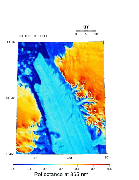
Petermann Glacier, Fjord, and Ice Island on July 31, 2012 at 08:05 UTC. Nares Strait is to the top left. Petermann Glacier, Greenland is on bottom right. PII-2012 is at the center.


At the southern entrance to Nares Strait, lots of multi-year ice is piling up near the constriction of Smith Sound. Winds and currents from the north usually flush this ice into Baffin Bay to the south, however, the same winds and currents will move the ice island out of Petermann Fjord and into Nares Strait. We will need patience, humility, and luck to get where we need to be to recover our instruments and data. A challenge that cannot be forced, we will likely wait and go with the flow rather than fight nature. We will have to play it smart. We are the only search and rescue ship for others. I am nervous, because this year looks far more difficult than did 2003, 2006, 2007, or 2009. In 2005 we were defeated by the winds, but that is a story for a different day.

The currents and winds of Nares Strait

[Editor’s Note: Undergraduate Allison Einolf of Macalester College in Minnesota summarizes her work at the University of Delaware that was supervised by Andreas Muenchow as part of an NSF-funded summer internship.]

I’m about to fly to Thule, Greenland for a research expedition into the Nares Strait. We had planed to survey Petermann Fjord, but our proposed cruise track is facing an obstacle twice the size of Manhattan.

We’re heading up north to pick up instruments that have recorded current velocities, salinity, temperature, and ice thickness in Nares Strait since 2009. I’ve been working all summer on data retrieved on a similar cruise three years ago, focusing on what effects the ice arches have on currents north of the ice arches.

Nares Strait MODIS satellite imagery of the study area and ice arch April 21, 2008. Red dots are instrument locations. Arrows show current velocities.

Nares Strait MODIS satellite imagery of the study area and ice arch April 22, 2009. Red dots are instrument locations. Arrows show current velocities. Note the lack of the southern ice arch, but the presence of one north of the study area.

Continue reading

Oceanography of Petermann Fjord and Glacier Melting

Trudy Wohlleben just send a group of scientists in Denmark, England, Canada, and the US the latest RADARSAT image of the ice island that formed in Petermann Glacier earlier this week.

RadarSat Image of Petermann Ice Island (PII-2012) and Glacier kindly provided by Trudy Wohlleben, Canadian Ice Service. The location of the hinge line is approximate only.

The current position of the remaining ice shelf of Petermann Glacier is the farthest landward since recorded observations. Dr. Croppinger was the first to provide a map of the glacier Continue reading

Petermann Glacier, Ice Islands, and Changing Climate

Petermann Glacier is a tidewater glacier in the remote north-west of Greenland. The glacier is grounded at about 600-m below sea level. It has calved two large ice islands, a 4-Manhattan sized island in 2010 and a 2-Manhattan sized one in 2012. These losses cover much of the area shown in this 2009 photo:

Eastern wall of Petermann Fjord as seen from CCGS Henry Larsen’s helicopter in August 2009 with the floating ice shelf. Most of the visible ice shelf has been lost during the 2010 and 2012 calving events. [Photo Credit: David Riedel, British Columbia.]

From selected imagery, I created a short movie (0.7 MB) which shows (a) the 2010 calving, (b) the advance of the new front in 2011 and early 2012, and (c) the 2012 calving. The glacier has moved at a rate of about Continue reading

Petermann Ice Islands Stuck in Ice

Several pieces of the Manhattan-sized ice island that broke off Petermann Glacier, Greenland in 2010 arrived, dispersed, and melted off Newfoundland last summer. They provided stunning displays visible to the naked eye from the coast. The Canadian Ice Service just distributed this set of radar images showing 4 pieces that are all grounded and/or stuck in ice. None are moving.

Overview of fragments of Ice Islands that broke off Petermann Glacier, Greenland in 2010 as of June-11, 2012 from RadarSat composites. [Credit: Luc Desjardins, Canadian Ice Service]

In the open ocean ice is moved by winds stressing the ice from above and by ocean currents stressing the ice from below. Typical sea ice varies in thickness from 1-5 meters (3-15 feet) which is much less than the 30-130 meters (90-400 feet) thick ice islands. Winds thus push thick ice islands much less than they do push the thinner sea ice. Thick ice islands are moved by ocean currents, not winds.

This is why oceanographers like myself love these bits of ice islands to bits: they tell us about the ocean below the surface that satellites do not see, but, sadly, all fragments are stuck either to the seafloor in shallow coastal waters or are cemented in place by immobile sea ice that is “land-fast:” Think of it as ice that is glued to land and to each other. This sheet of glued-together ice extends some distance offshore. The distance can be a few yards during a cold winter night in Maine or 100s of miles off Siberia. Offshore islands, rocky outcroppings, or grounded ice islands all anchor land-fast ice by adding local support and thus strength and stability to the immobile land-fast ice.

Too much talk, lets explain this with an image of the largest ice islands, called PII-B1. It is about 4 km wide and 9 km long. I dropped a black dot in its center as it is hard to see where to look in this image. I also show land in grey, open water in blue, and ice in shades of white and yellow:

Land-fast and mobile sea ice off Baffin Island with Petermann Ice Island PII-B1 grounded near the 150 meter isobath (black dot). Thick lines are 100, 200, and 300-m bottom depths. MODIS Terra data at 250-m resolution from June-6, 2012, 15:05 UTC.

There is clearly a 30-km wide band of ice attached to the land with a line of blue water separating it from ice that is mobile and has different signatures. A blue band of ocean has emerged, I speculate, as the result of winds from the south that moved the mobile ice to the north-east (to the right in the image). Neither the land-fast nor the grounded ice island PII-B1 embedded in it moved, so open water appears where there was mobile ice before. This is called a shore lead and I bet there are plenty of seals and whales feasting there now. Note also the arched entrance to Home Bay (bottom left) where loose ice is scattered towards the headland of Henry Kater Peninsula.

As summer is arriving fast in the Arctic, the land-fast ice will disappear, breaking up as the sun and air above and the ocean below weakens the ice by melting. This will expose the thicker ice islands and icebergs to wind-forced storms and waves more violently than it does now. And even those ice island grounded to the bottom of the ocean in shallow water will become free during a time of higher than normal sea level, perhaps during a spring tide, perhaps during strong winds from the north. Then these currently stuck-in-the-ice ice islands will continue their journey south towards Newfoundland and the Atlantic Ocean that they began in 2010 when they were born in northern Greenland.

EDIT: For context I append an earlier RadarSat image from October-18, 2010 when all segments were much closer in space.

Petermann Ice Islands in northern Baffin Bay of Coburg Island, Canada at 76 N latitude on Oct.-18, 2010, about 2 month after they separated from Petermann Glacier, Greenland at 81N latitude. [Credit: Luc Desjardins, Canadian Ice Service]