Tag Archives: climate change

How oceans interact with Greenland’s last floating glaciers

Testifying before the US Congress back in 2010, I refused to endorse the view that a first large calving at Petermann Gletscher in North Greenland was caused by global warming. When a second Manhattan-sized iceberg broke off in 2012, I was not so sure anymore and looked closely at all available data. There was not much, but what little I found suggested that ocean temperatures were steadily increasing. Could it be that warm waters 1000 feet below the surface could melt the glacier at all times of the year? Did this melting from below thin the glacier? Did these changes increase the speed at which it moves ice from land into the ocean? These were the questions that motivated a number of projects that began in earnest in 2015 aboard the Swedish icebreaker I/B Oden. Professional videos of this expeditions are at https://icyseas.org/2019/07/04/petermann-glacier-videos-science/

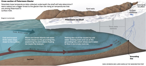
Scientists and technicians from the British Antarctic Survey drilled three holes through the floating section of Petermann Gletscher to access the ocean and ocean sediments below it. The ocean temperature and salinity profile confirmed both the warming trend observed in the fjord and ocean adjacent to the glacier, but more importantly, we placed ocean sensors below the glacier ice to measure temperature and salinity every hour for as long as the sensors, cables, and satellite data transmission would work. This has never been done around Greenland, so our data would be the first to report in real time on ocean properties below 100 to 300 m thick glacier ice at all times. What we saw when the data started to come in after 2 weeks, a month, and half a year stunned us, because (a) the ocean waters under the glacier changed by a very large amount every two weeks. Nobody has ever seen such regular and large changes in tempertures (and salinity) under a glacier bathed in total darkness at air temperatures of -40 degrees Celsius and Fahrenheit, but then our station went offline after 6 months and did not report any data to us via satellite.

Helicopter flight path on 27/28 August 2016 to reach Petermann Gletscher (PG) via southern (Fuel-S) and northern (Fuel-N) fuel stops in northern Inglefield and southern Washington Land, respectively. Background color is ocean bottom depth in meters.

Refurbished Petermann Glacier Ocean Weather station on 28. August 2016 with Greenland Air helicopter and British Antarctic radar station in the background.

The first work on the grant was to visit our station by helicopter in 2016 using two fuel caches that we placed the year prior from the Swedish icebreaker. At this point Petermann Gletscher and our projects attracted the attention of journalists of the Washington Post who had read some of the blog articles at this site. The two journalists accompanied us for a week and produced a beautiful visual report of our work that is posted at

https://www.washingtonpost.com/sf/business/2016/12/30/with-enough-evidence-even-skepticism-will-thaw/

A detailed news report on our science and new findings appeared on page-1 of the Washington Post on January 1, 2017 [Broader Impacts]. I briefly summarize the results and findings of our subsequent data analyses of all data from August of 2015 through October of 2017 [Intellectual Merit]:

1a. Ocean temperatures increase at all five depths below the 100-m thick floating ice shelf of the glacier. These warmer waters are also saltier which demonstrates their Atlantic origin.

1b. Surface sensors indicate short, but intense pulses of meltwater passing our ocean array at spring-neap tidal cycles.

2a. Melt rate data reveal that these pulses occur during reduced tidal amplitudes and follow peaks in glacier melting that exceeded 30 feet per year.

2b. Statistical analyses indicate that the melt waters originate from a location near where the glacier sits on bed rock and that the melt water then moves seaward towards the ocean.

3a. Ocean melting below the glacier varies from summer (strong) to winter (weak) rising from a winter mean of 6 feet per year to a maximum of 240 feet per year during the summer.

3b. The large summer melting is caused by the increased discharge of subglacial runoff into the ocean near the grounding line.

3c. The larger discharge strengthens ocean currents under the floating glacier that drive ocean heat toward the glacier’s ice base.

The work formed one basis for the dissertation of PhD student Peter Washam who published the items #2 and #3 in the Journal of Physical Oceanography and Journal of Glaciology, respectively. He helped to drill holes and install sensors for the project that we first described at #1 in Oceanography. These three peer-reviewed journal articles are all published by not-for-profit professional organizations and societies dedicated to higher learning and public outreach. Furthermore we placed three separate data sets (1 | 2 | 3) at the Arctic Data Center that is funded by the National Science Foundation. More will come as we continue to work on the hard-won data from below Petermann Gletscher.

Look down the 0.3 meter wide drill hole. Yellow kevlar rope supports cable and ocean sensors.

Post Scriptum:
A modified version of the above was submitted the US National Science Foundation as part of the final reporting on grant 1604076 (“Glacier-Ocean interactions at a Greenland ice shelf at tidal to interannual time scales”) that funded this work with $360,400 at the University of Delaware from August 2016 through July 2019.

Scoresby Sund – Greenland’s Longest Fjord

Fog, fog, and more fog is all we saw as we approached Scoresby Sund aboard the German research ship Maria S. Merian from Denmark Strait to the south-east. The fog lifted as soon as we passed Kap Brewster and began work on ocean currents and waters at the entrance of this massive fjord system. My artist friend and wife Dragonfly Leathrum posted a wonderful travel essay with many photos that did not include these:

We were here to explore how the coastal ocean off Greenland may relate to Daugaard-Jensen Gletscher at the head of the fjord some 360 km away (195 nautical miles or about a day of constant steaming at 8 knots). This tidewater glacier discharges as much icy mass out to sea as does Petermann Gletscher or 79N Glacier to the north or half as much as Helheim, Kangerdlugssuaq, and Jacobshavn Glaciers to the south. Unlike all those other glaciers, Daugaard-Jensen and its fjord are still largely unexplored.

Location Map of Scoresby Sund. Kap Brewster is at bottom right while Daugaard-Jensen Gletscher 360 km away is near the top left.

Location Map of Scoresby Sund. Kap Brewster is at bottom right while Daugaard-Jensen Gletscher 360 km away is near the top left.

Part of the chart of the East Greenland coast drawn up by William Scoresby Jr. in 1822, showing the numerous features that he names in Liverpool land (Liverpool Coast) and adjacent areas. From: Scoresby (1823)

Part of the chart of the East Greenland coast drawn up by William Scoresby Jr. in 1822, showing the numerous features that he names in Liverpool land (Liverpool Coast) and adjacent areas. From: Scoresby (1823)

While the entrance between Kap Tobin and Kap Brewster was known to whalers in the early 19th century, it was William Scoresby Sr. after whom the fjord is named. His scientist son William Scoresby Jr. mapped coastal Greenland between 69.5 and 71.5 North latitude during his last voyage in 1822. Nobody entered the fjord until 1891 when Lt. Carl Ryder of the Danish Navy sailed deep into the fjord to explore the area for a year with 10 companions. They built a hut next to a natural port that they named Hekla Harbor. Amazingly, they also measured ocean temperature profiles almost every month from the surface to 400 m depth. I found these data at the National Ocean Data Center of the United States Government.

Ocean temperature (left panel) and salinity (right panel) as it varies with depth in different years. Blue represents measurements from 1891/92, red from 1990, and black from 2018.

Ocean temperature (left panel) and salinity (right panel) as it varies with depth in different years. Blue represents measurements from 1891/92, red from 1990, and black from 2018.

Searching for data from Scoresby Sund, I found 17 profiles of water temperature with data from at least 10 depths. Funny that 12 of these profiles were collected in 1891 and 1892 while the other 5 profile contain salinity measurements made in 1933, 1984, 1985, 1988, and 2002. The 1988 cast was taken by an Icelandic vessel and also contained continous data from a modern electronic sensor rather than waters collected by bottles. I “found” another 4 modern sensor profiles collected in 1990 at the Alfred-Wegener Institute in Germany.

That’s pretty much “it” … until we entered the fjord in 2018 when we collected another 27 casts thus more than doubling the ocean profiles. More exciting, though, is the very large shift in ocean temperatures from 1990 to 2018. The 1990 temperatures are very similar to the 1891/92 temperatures, but all old temperatures (also from 1933 and 1985, not shown) are all about 1 degree Celsius (2 degrees Fahrenheit) cooler than those we measured in 2018. Why is this so? Does such warming originate from outside the fjord? If so, how does the warmer Atlantic water at depth in deep water crosses the 80 km wide shallow continental shelf to enter Scoresby Sund? Are any of these ideas supported by actual data? What data are there?

Ocean data location off eastern Greenland collected from 1890 to 2010 that reside in NODC archives. Red are water bottle data while yellow are modern electronic sensor measurements. The white box bottom left is the entrance to Scoresby Sund. Light blue areas are water less than 500 m deep while dark blue shades are deeper than 1000 m.

Ocean data location off eastern Greenland collected from 1890 to 2010 that reside in NODC archives. Red are water bottle data while yellow are modern electronic sensor measurements. The white box bottom left is the entrance to Scoresby Sund. Light blue areas are water less than 500 m deep while dark blue shades are deeper than 1000 m.

Discoveries in science can be pretty basic, if one is at the right location at the right time with the right idea. Also, there is more data to the south that I did not yet look at to investigate the question of what causes the warming of bottom waters in Scoresby Sund.

EDIT Dec.-31, 2019: Replace “warmer” with “cooler” when comparing 1891 and 1990 (cooler) to 2018 (warmer) water temperatures.

Two Years Ocean Observing Below Petermann Glacier Greenland

A year ago today I last set foot on Petermann’s floating ice shelf. The 28th of August 2016 was a drizzly, cloudy day with water running over the surface of the glacier in small streams emptying into larger streams to form small rivers that merged into larger channels carved into the ice. Two years ago Keith Nichols and I set-up a weather station atop the glacier. Many friends helped. We connected copper wires, ocean sensors, and a surface station to collect data from sensors 100-m below the ice in 800-m deep water. The small 2015 project of opportunity keeps giving us hourly ocean data. I am still stunned by our luck and technology.

My Petermann story started in 2010 when a first Manhattan-sized ice cube broke off the glacier. Two days after a University of Delaware press release, the US Congress asked me to appear before one of its inquiring committees. I humbly acknowledged how little I knew then, but everyone else knew even less. In 2012 another Manhattan-sized glacier piece broke off. While satellite a image shows what happens, only hard ocean data and modeling explains why it happens. Two research proposals were rejected, sadly, to probe ocean physics with carefully designed experiments, but in 2016 Alan Mix invited me to an expedition to Petermann aboard the Swedish icebreaker Oden. I gladly accepted, but I wanted to contribute something. That “something” became the Petermann Glacier Ocean Weather Observatory.

Alan needed holes drilled through the 100-m to 400-m thick glacier. Actually, he needed mud from 800 meters below the glacier. Keith Nichols of the British Antarctic Survey drilled those holes for Alan and collected the mud. My plan was to recycle the hole, that is, we dropped kevlar line, copper wire, and ocean sensors into the ocean and connected all to a weather station. David Huntley and I designed the system that included an Iridium satellite phone. Iridium phone calls ceased in February 2016, but a “service call,” that is, a helicopter site visit fixed the station. Chris Mooney and Whitney Shefte told the story for the Washington Post on 30 December 2016.

Ocean temperature at 95-m, 300-m, and 450-m below the sea surface as well as pressure at the bottom sensor near 810-m depth (~810 dbar pressure) updated through 27 August 2017.

The graph shows the entire 2-year long data record. Each gray vertical bar indicates a month between July 2015 and December 2017. The top record shows ocean temperatures just below the floating glacier ice. It was a surprise to see the data change from -0.3 Celsius to -1.6 degrees Celsius. The latter is close to the freezing point of salt water. Hence I interpret low-temperature events as meltwater pulse that swoosh past our sensor.

At 300-m we find a smaller range of temperatures near +0.1 degrees Celsius. Note the steady increase of temperature. Fluctuations are similar, but their absolute values increase with time. The linear warming trend becomes clear at 450-m depth, because the fluctuations diminish, but the warming does not. Temperatures at all depths increased over the entire two years of hourly observations.

The pressure record of the bottom-most sensor on the kevlar line perplexes me: During the first year the sensor slides into deeper water, because the kevlar stretches as all lines do when weighted down. In July 2016 the sensor sharply rises by almost 3 meters from 810.5 to 808.5 dbar to just as rapidly drop again to the 810.5 dbar value. The same feature occurs in the summer of 2017 also. It relates to the summer melt season, but how? I do not know.

The 2-year record is not perfect as the many gaps indicate. These result from electronic and mechanical failures that, I feel, are caused by long and harsh winters when temperatures dropped below -40 degrees Celsius or Fahrenheit. These cold temperatures challenge the best batteries during the 4-5 months of total darkness. On 20. December 2016 our batteries ran out and shut down the station. The sun revived our data gathering when the solar panels recharged batteries in March 2017.

The glacier also melts about 1-2 meters at the surface each summer. This surface melt tilted and almost crashed the station that we repaired last year today. In 2015 we had 2-m of pipe to fix into the glacier ice. In 2016 we replaced this with a 4-m pole that should survive two year’s of surface melt, I hope.

There are many, many people who all contributed in ways both small and large. It takes a village to raise a station on Greenland:

Is Petermann Gletscher Breaking Apart this Summer?

I am disturbed by new ocean data from Greenland every morning before breakfast these days. In 2015 we built a station that probes the ocean below Petermann Gletscher every hour. Data travels from the deep ocean via copper cables to the glacier surface, passes through a weather station, jumps the first satellite overhead, hops from satellite to satellite, falls back to earth hitting an antenna in my garden, and fills an old computer.

A 7-minute Washington Post video describes a helicopter repair mission of the Petermann data machine. The Post also reported first result that deep ocean waters under the glacier are heating up.

Sketch of Petermann Gletscher’s ice shelf with ocean sensor stations. The central station supports five cabled sensors that are reporting hourly ocean temperatures once every day. Graphics made by Dani Johnson and Laris Karklis for the Washington Post.

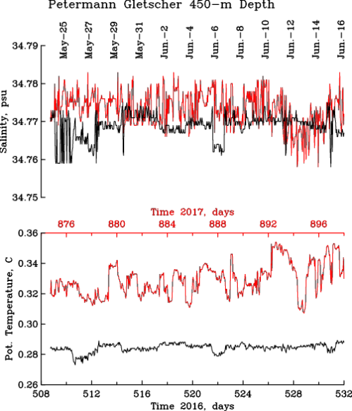
After two years I am stunned that the fancy technology still works, but the new data I received the last 3 weeks does worry me. The graph below compares ocean temperatures from May-24 through June-16 in 2017 (red) and 2016 (black). Ignore the salinity measurements in the top panel, they just tell me that the sensors are working extremely well:

Ocean temperature (bottom) and salinity (top) at 450-m depth below Petermann Gletscher from May-25 through June-16 2017 (red) and 2016 (black). Notice the much larger day-to-day temperature ups and downs in 2017 as compared to 2016. This “change of character” worries me more than anything else at Petermann right now.

The red temperature line in the bottom panel is always above the black line. The 2017 temperatures indicate waters that are warmer in 2017 than in 2016. We observed such warming for the last 15 years, but the year to year warming now exceeds the year to year warming that we observed 10 years ago. This worries me, but three features suggest a new ice island to form soon:

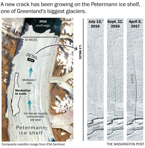
First, a new crack in the ice shelf developed near the center of the glacier the last 12 months. Dr. Stef Lhermitte of Delft University of Technology in the Netherlands discovered the new crack two months ago. The new rupture is small, but unusual for its location. Again, the Washington Post reported the new discovery:

New 2016/17 crack near the center of Petermann Gletscher’s ice shelf as reported by Washington Post on Apr.-14, 2017.

Second, most Petermann cracks develop from the sides at regular spaced intervals and emanate from a shear zone at the edge. Some cracks grow towards the center, but most do not. In both 2010 and 2012 Manhattan-sized ice islands formed when a lateral crack grew and reached the central channel. The LandSat image shows such a crack that keeps growing towards the center.

Segment of Petermann Gletscher from 31 May 2017 LandSat image. Terminus of glacier and sea ice are at top left.

And finally, let’s go back to the ocean temperature record that I show above. Notice the up and down of temperature that in 2017 exceeds the 2016 up and down range. Scientists call this property “variance” which measures how much temperature varies from day-to-day and from hour-to-hour. The average temperature may change in an “orderly” or “stable” or “predictable” ocean along a trend, but the variance stays the same. What I see in 2017 temperatures before breakfast each morning is different. The new state appears more “chaotic” and “unstable.” I do not know what will come next, but such disorderly behavior often happens, when something breaks.

I fear that Petermann is about to break apart … again.

North Greenland Sea Ice: Wolstenholme Fjord and Thule Air Base

Greenland hunters, seals, and polar bears all need sea ice atop a frozen ocean to eat, breath, or live. The sea ice around northern Greenland changes rapidly by becoming thinner, more mobile, and less predictable as a result of warming ocean and air temperatures. I will need to be on the sea ice to the north and west of Thule Air Base in March and April about 6 weeks from to conduct several connected science experiments. The ice should be “land fast,” that is, it should be a solid, not moving plate of ice. The work is funded by the National Science Foundation who asked me to prepare a sea ice safety plan to keep the risk to people working with me to a minimum. In a science plan I included this satellite image of what the ice and land looked like in march of 2016:

Optical satellite image of Wolstenholme Fjord, Greenland on March-21, 2016 with Thule Air Base in bottom right. Darker areas show thin ice.

Optical satellite image of Wolstenholme Fjord, Greenland on March-21, 2016 with Thule Air Base in bottom right. Darker areas show thin ice.

This LandSat image captures the reflection of sun light during a cloud-free day at ~15 m pixel size. No such imagery exists for 2017 yet, because the sun does not set until late February with this US satellite overhead. The European Space Agency (ESA), however, flies a radar on its Sentinel satellite. This radar sends out its own radio waves that are then reflected back to its antenna. The radar sees not only during the polar night, it can also see through clouds. And ESA provides these data almost instantaneous to anyone who wants it and knows how to deal with large data files. If you think your 8 mega pixels are sharp, these images are closer to 800 mega pixels. Here are three such images from January 3, 24, and 28 (yesterday):

The lighter white tones indicate that lots of radar signals return to the satellite. The many tiny white specks to the south of the Manson Islands are grounded icebergs. The different shades of gray indicate different types of ice and snow. The Jan.-24 and Jan.-28 images show a clear boundary near longitude of -70 degrees to the north of the island (Saunders Island) that separates land-fast ice to the east from thinner and mobile ice in Baffin Bay to the west.

I plan to work from Thule Air Base (red dot bottom right) out along points C, B, towards A. The color of line near these points is a section where I have very accurate bottom depth from a 2003 US Coast Guard Icebreaker that was dropping off scientists at Thule on August 15, 2003. I was then one of the scientist dropped off after a 3 week excursion into Nares Strait and Petermann Fjord. Along this section I hope to test and deploy and under-water acoustic network that can send data via whispers from C to A via B. First, however, we will need to know how sound moves along this track and before that, for my ice safety plan, I will need to know how thick or thin the ice is. The imagery does not tell me ice thickness.

Flying to Thule Greenland with US Air force Air Mobility Command delivering cargo and people.

Flying to Thule Greenland with US Air force Air Mobility Command delivering cargo and people.

Arriving in Thule on Mar.-8, we will first need to measure ice thickness along this A-B-C section with a sharp ice-cutting Kovacs drill and a tape measure. The US National Snow and Ice Data Center (NSIDC) distributes a “Handbook for community-based sea ice monitoring” that we will follow closely. This first ice survey will also give us a feel and visual on how the radar satellite imagery displays a range of ice and snow surfaces. One of my PhD students, Pat Ryan, will process and send us the ESA Sentinel-1 radar data while a small University of Delaware and Woods Hole Oceanographic Institution group will work on the ice in early April.

The mental preparation for this scientific travel to Thule and the sea ice beyond gives me the freedom and pleasure to explore new data such as Sentinel-1 imagery and perspectives on tremendous local traditional knowledge of the Inugguit who have lived with the sea ice for perhaps 4000 years. The town of Qaanaaq is 45 minutes by helicopter to the north of Thule Air Base (TAB) at Pituffik. The town was established in 1953 when local populations living in the TAB area were forcibly removed. Despite these challenges the displaced people have prospered throughout the Cold War, but a less predictable and rapidly changing sea ice poses a severe threat to the community whose culture, health, and livelihood still depends on hunting and traveling on sea ice. Stephen Leonard is an anthropological linguist at the University of Cambridge who lived in Qaanaaq for a year in 2010/11 when he made this video:

P.S.: If possible, I would very much like to work with a local person who knows sea ice and wild life that we would need protection from. Danish contacts are reaching out on my behalf to people they know in Siorapaluk, Qaanaaq, and Savissivik.