Tag Archives: Crowd-Funding

Tribal Interactions and Arctic Research

Arctic field work connects people of different backgrounds, disciplines, and tribes. Last week I spent 3 days in Maine where I met with Arctic archeologists, anthropologists, and students of all ages. Susan Kaplan and Genevieve LeMoine run the Arctic Peary-McMillan Museum and do extensive field work in Labrador, Cape Sheridan atop Ellesmere Island (Canada), and northern Greenland. A class of smart sophomore asked more questions than I could answer in the morning and a diverse group of citizen did the same in the evening. I represented the “physics tribe.”

We learnt of each other after I posted an illustrated essay “Ruins of Fort Conger” that contained this image taken near Petermann Fjord in 2012

Fort Conger rebuilt 1900 by Peary

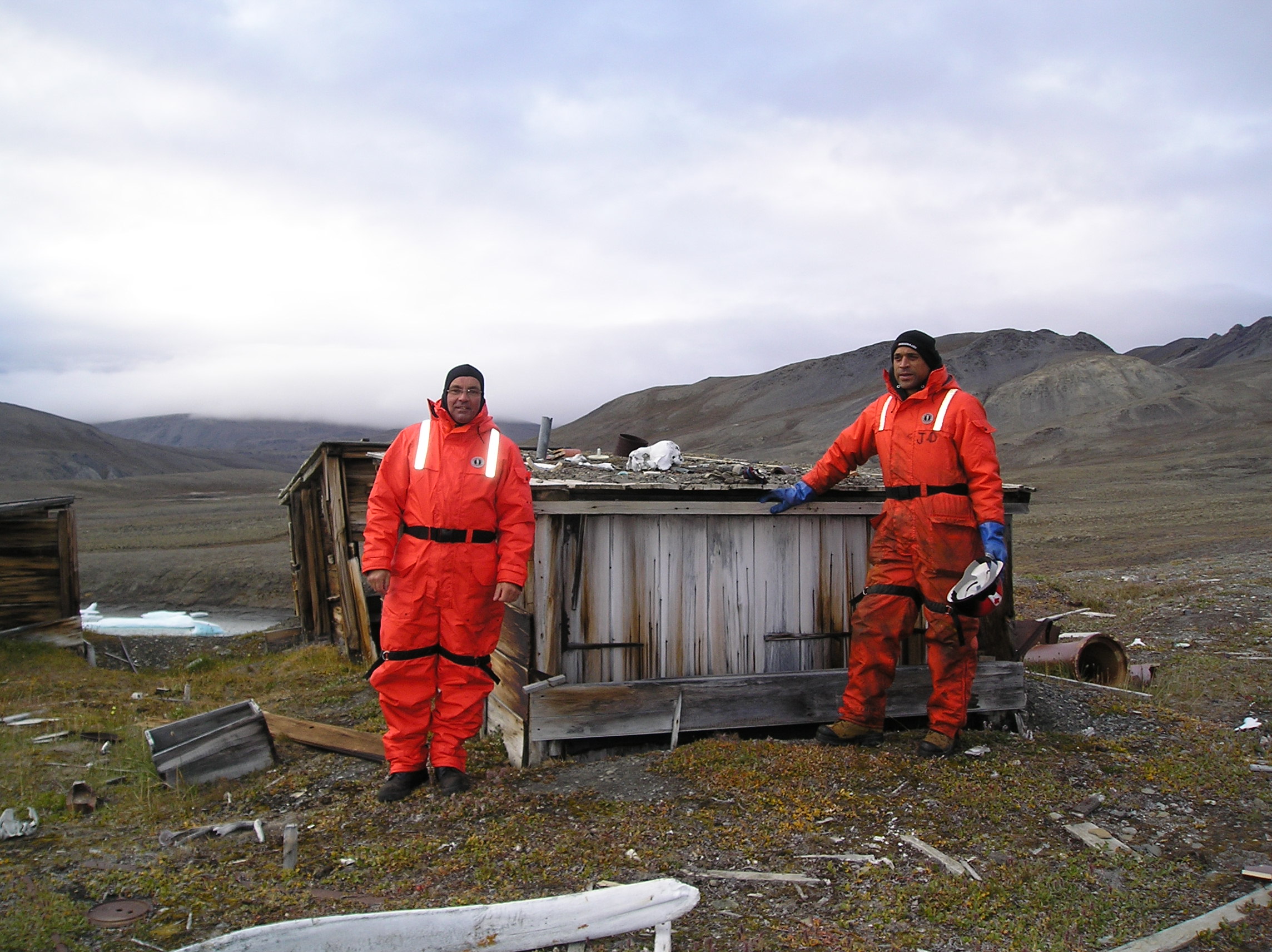
Carl Rose on the left was a seaman on our last 2012 expedition while Jonathan Poole is a marine field technician with whom I work often. They stand before a hut built by Admiral Robert Peary in 1900 on one of his early excursions to reach the North Pole. The 2012 photo bears remarkable similarity to one taken in 1909 that Genevieve LeMoine describes on her blog with title “Tides of the Arctic.”

Donald MacMillan and Jack Barnes at Fort Conger, spring 1909 [From LeMoine, 2013]

Donald MacMillan and Jack Barnes at Fort Conger, spring 1909 [From LeMoine, 2013]

It shows Donald McMillan and Jack Barnes in 1909 during a later Peary expedition. The pictures and histories are displayed at the “Glimmer of the Polar Sea” exhibition at the Bowdoin’s Peary-McMillan Arctic Museum. These huts are the closest “shelter” to Petermann Fjord about 50 miles to the east. The men visiting Fort Conger in 1909 and 2012 look towards the ocean which in 2012 looked like this

Discovery Harbor off Fort Conger, Ellesmere Island as seen from helicopter in 2012.

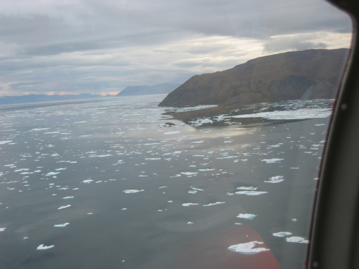
Discovery Harbor off Fort Conger, Ellesmere Island in 2012.

We visited the site in 2012 to recover an ocean sensor that, so we hoped, had measured tides and temperatures for 9 years earlier. For 9 long years we had no way to tell, if either sensor or data existed. Only after recovery in 2012 did we jubilantly find sensors and data. At the time we deployed this sensor in 2003 technology did not exist to get data out from the ice-covered ocean. We are trying to develop technology to change this. The non-trivial goal is to get such data out as it is collected without waiting for 9 years. That’s what my crowd-funding project is about: Develop new technologies and share all data, results, and excitement.

If funded, this project will produce results immediately as ocean temperatures (and salinities) will be transmitted to the word wide web for anyone to use as she or he sees fit. Please help and be part of the cutting edge of Arctic Oceanography: Tell your friends, tell your family, and tell your colleagues about the science, about the Arctic, about the beauty, about the climate, and about the physics of the ocean.

Greenland Glacier Ocean Warming

The Swedish icebreaker Oden will visit Petermann Fjord in northern Greenland in 6 months time. The US National Science Foundation (NSF) funded a large geophysical and geological experiment after excruciating peer-review over a 4-year period. The experiment shall reveal climate histories from sediment cores, geomagnetics, and both bottom and sub-bottom sonar profiling. Besides this main mission Oden also supports several smaller auxiliary projects some of which are funded by NSF while others are not. It will be a fine collaboration between Swedish and American scientists working together in perhaps one of the most difficult to reach and beautiful places on earth.

Seaward front of Petermann Glacier Aug.-11, 2012. View is from a small side-glacier towards the south-east across Petermann Fjord with Petermann Gletscher to the left (east). [Photo Credit: Erin Clarke, Canadian Coast Guard Ship Henry Larsen]

Seaward front of Petermann Glacier Aug.-11, 2012. View is from a small side-glacier towards the south-east across Petermann Fjord with Petermann Gletscher to the left (east). [Photo Credit: Erin Clarke, Canadian Coast Guard Ship Henry Larsen]

I will aboard the ship to deploy sensors some of which exist and are funded while others are neither. Let me outline first the funded part and then part where you the reader and I can perhaps join forces. First, we will test first elements of an underwater acoustic communication system. Think cell-phones, except the phone towers are under water where they are called modes. The modems talk to each other by sending sound back and forth the same way that whales do talk to each other.

Here is a narwhals sound

that you can use as a ringtone, credit goes to Voices of the Sea web-site at Scripps Institution of Oceanography. These whales visit Petermann Fjord in summer and we saw many of them frolicking in August of 2012 when I visited the area with the Canadian Coast Guard whom I credit for these photos:

Our man-made sound is very quiet, but because it is quiet, it only moves 3-10 km through the water. To increase our range, we plan to install several quiet sound sources that whisper from one water-phone (=hydrophone) to the next. The goal is to get data from ocean sensors moved along this whispering system of underwater “cell phones” to reach a listening station that we plan to install at the edge of Petermann Gletscher’s floating ice shelf. The ice is 200 meters or 600 feet thick and it is not trivial to drill through that much ice, but it can be done, and the British Antarctic Survey is aboard with a team of experts to do so to get sediment cores from the bottom below the ice:

Makinson1993-Fig04

Today I ordered a first cable that will connect the underwater modem hanging under the 200-m thick ice to the surface where a fancy computer connects it to the internet via to a satellite phone. All data calls that the underwater listening station receives will move up the cable to the glacier surface and on to us all via the internet. This challenging engineering project is funded, but I like to use the same hole, computer, and satellite link to get additional ocean and air data.

Additional stations will be drilled through the ice-shelf farther inland to reach the ocean also. Here we also need cables and instruments that tells us how the glacier is melted by the ocean at different location along its 50 km long floating ice shelf. The incremental costs are small relative to the cost of getting a ship and helicopters there, but NSF cannot easily fund small projects rapidly. It takes a long time to pass scientific peer review. This is where you, my dear reader come in: I need your help to raise $10,000 to add science and observations to an engineering feasibility study that is the underwater whispering sound system.

The motivation and details are described with videos, pictures, laboratory notes, plots, ideas, as well as some short, quirky, yet technically correct descriptions at the crowd-funding site

https://experiment.com/projects/ocean-warming-under-a-greenland-glacier.

I created and launched it today, it will be up for 30 more days. If you can and if you like the science, work, and fun that I describe on these pages, please consider making a small donation. You have the power to make this happen and I will share all data both from below and above the ocean and glacier surface with you.

As a physicist, gardener, teacher, writer, traveler, ping-pong player, and geocacher I am naturally curious about both our natural and social world. I love experiments and to me the crowd-funding at Experiment.com is a most enjoying experiment to connect to people in a new way. Full disclosure, however, this company takes 8% of all funds generated to supports its wonderful software and staff. Perhaps you like to join this experiment by spreading the word and, if you can afford it, help pay for some of the technology needed to bring Greenland and its mysteries to everyone who wants to connect to it.