
Petermann Glacier is a tidewater glacier in the remote north-west of Greenland. The glacier is grounded at about 600-m below sea level. It has calved two large ice islands, a 4-Manhattan sized island in 2010 and a 2-Manhattan sized one in 2012. These losses cover much of the area shown in this 2009 photo:

Eastern wall of Petermann Fjord as seen from CCGS Henry Larsen’s helicopter in August 2009 with the floating ice shelf. Most of the visible ice shelf has been lost during the 2010 and 2012 calving events. [Photo Credit: David Riedel, British Columbia.]
From selected imagery, I created a short movie (0.7 MB) which shows (a) the 2010 calving, (b) the advance of the new front in 2011 and early 2012, and (c) the 2012 calving. The glacier has moved at a rate of about 1 km per year (Higgins, 1991) or about 6 miles per decade. After the removal of the 2010 4-Manhattans it increased its speed by about 10-20%, noticeable, but not dramatic. Then, yesterday, a second ice island formed along a large lateral crack that Mauri Pelto described in 2008 and updated in 2011. He correctly predicted the loss of a 150 km^2 sized ice island as a result of that crack. This is exactly what we got yesterday: an ice island forming at precisely this crack which has moved seaward at a rate of 1.0-1.3 km per year for at least the last 6 years.
The perhaps best image of the new ice island, lets call her PII-2012 will tomorrow become the Canadian Ice Service’s Canadian Ice Service’s Image of the Month:”

Canadian Ice Service’s July 2012 “Image of the Day” showing PII-2012 formation from RADARSAT-2 data taken on Jul-16, 12:23 UTC. [Courtesy of Trudy Wohleben, Canadian Ice Service.]
While these losses of floating ice from Petermann Glacier seem large (370 km^2 or 6 Manhattans for 2010 and 2012), and they are large in area, they give only about 10-20% of the total mass lost. The dominant mass loss is via ocean melting from below. This dominant process is not visible, it is not possible to capture it with eye-catching images. Furthermore, and this appears counter-intuitive, the loss of area will have little direct effect on the ocean melting, because the 100-150 thick floating ice shelf is bathed in ocean water near the freezing point.
Most of the ocean melting takes place near the hinge line, that is, the place where Greenland’s bed rock meets both the ocean water of Petermann Fjord and the ice sheet of Greenland at a depth of about 600 meters. The ice from Greenland’s ice sheet moving into Petermann Fjord is 600-700 meters thick. This hinge-line is 50 km landward from the current edge of the glacier, yet, 20 km seaward from the hinge-line, the ice is only 100-200 meters thick.
The heat to melt Petermann Glacier comes from the Atlantic Ocean via a long and arduous pathway through the Arctic Ocean at 300 to 700 meters below the surface (Muenchow et al., 2011). This water enters Nares Strait and Petermann Fjord from the north. These Atlantic waters at depth melt Petermann Glacier from below within about 20 km of the hinge-line. Here, at 300-700 meter depth, the ocean temperatures are well above freezing, and these Atlantic waters are warming, but records are short, starting only in 2003 for Nares Strait.

Time series of temperature (bottom) salinity (top) from the bottom of the ocean in Nares Strait between northern Greenland and Canada (from Muenchow et al, 2011). Trends are indicated for the 2003-06 and 2007-09 periods.
The main worry on what happens at Petermann Glacier relates to the migration of the hinge-line which has not yet been observed. The scale and dynamics are somewhat similar to what is observed at Pine Island Glacier, Antarctica, where the hinge-line migrated backwards into a depression or subsurface basin which lead to much accelerated ice discharge and further retreat of the hinge-line there with attendant net sea level rise (NASA Animation).
Much of the topography of interior Greenland is depressed below sea level by the mass of the ice above it. Removing the ice in an instant, Greenland’s bed rock looks like this

Greenland’s bed-rock elevation from Bamber et al. (2003) digital elevation model based on remotely sensed surveys of the 1970ies and 1990ies gridded at 5 km resolution. The hinge line of Petermann Gletscher is indicated by black symbols, blue colors show bedrock below current sea level.

Same as above Bamber et al (2003) bedrock map, but for smaller area showing Petermann Glacier hinge-line.
I also show the location of other glaciers where much work has been done by glaciologists, oceanographers, and geophysicists over the last 30 years. The invisible hinge-line is the critical site where small changes in the present will determine large changes in the future. The hinge-line moves in response to tidal forcing, glacial flow dynamics, and a changing climate. All of this both impacts and is impacted by the ice, the ocean, the air at times scales ranging from years to millennia. We have barely started to understand all these interacting processes, but it is an exciting time of change. Some changes are dramatically visible such as the discharge of large ice islands, some changes, perhaps more important, are not. In 3 weeks time I will be aboard the Canadian Coast Guard Icebreaker retrieving instruments from the bottom of Nares Strait that will show what is not easily seen.

Canadian Coast Guard Ship Henry Larsen at one of 100s small glaciers discharging into Petermann Fjord in August of 2009. [Photo Credit: Helen Johnson, University of Oxford]


So given the recent retreat, how do you see this impacting basal melt flux. Much less bottom are to work at, but given the fact that most of the melt is where the ice shelf is thicker, not the thin more extensive tongue, will it change much. Will the physical oceanography change?
I doubt the oceanography will change much as a result. Vertical stratification does not change (cold, fresher water top 150-m and warm, salty below). The basal melting takes place near the hinge-line causing the ice thickness to change from 600 to 150 m in perhaps 10-20 km which is further inland. The exchange flow of Nares Strait with the fjord is not changing much either as the mobile ice or summer season is short for the added wind-stress to do much … and there already is more heat inside the fjord at depth NOT in contact with the ice, to melt the entire ice shelf.
I am still mystified by the melt-channels, though, that Rignot and Steffen (2008) report, not sure anyone knows what causes those and how they relate to either glacier or ocean dynamics or details of the geometry of the ice-shelf.
Maybe this is a silly question, but when can we expect another event like this one or that of 2010? I’m not seeing any major rifts, so it will take a while longer, right?
Yes, I feel the same way, it is not a silly question at all. The interesting part is, though, will the glacier accelerate? It did not accelerate much since 2010, no more than 10-20% perhaps, but PII-2010 did no have the same frictional connection to the side walls that PII-2012 had, especially on the south-western side. Time will tell. The critical question is how stable is the hinge-line? That’s the location where all the action, albeit out of reach.
Neven, the last two ice bergs were easy to see coming from the rifts. At present there are no obvious breaks, it will be interesting to see if one develops this summer. However, I anticipate it will be a longer process to form a rift and then calve an iceberg. We have been on a two year phase from a well developed rift nearest the front to then calve
It looks to me like the icestream joining the Petermann from the West is likely to cause the calving of a much smaller ice island at the break-face, imminently.
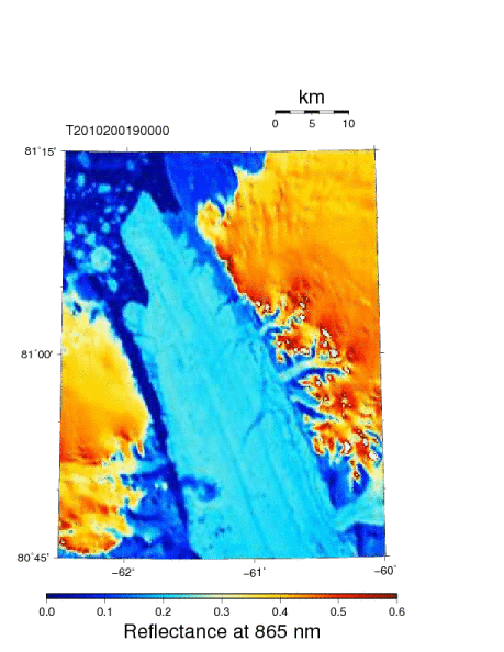
I am not sure, the RadarSat image https://icyseas.files.wordpress.com/2012/07/rsat2012_0720.png does not show much, but what I find fascinating is that each cape of each side-arm glacier is leaving a streamline as a marker that then will move downsream (seaward) with the glacier.
It is also possible, that the protuding piece on the western (left) side may move slower seaward than does the central portion of Petermann Glacier. The result would be a shear zone were perhaps a new future crack may form. At the moment I see no such thing, but it will be very interesting to see how the speed of the glacier will adjust and how this speed will vary across the Petermann Glacier.
Setting out a set of fixed GPS transmitters fixed deep into the currently attached ice would be a great way to measure this.
Pingback: Polar Blues | Scholars and Rogues
Pingback: Petermann Glacier Retreat 2010-Rift Extension-2011 Update-2012 Update « From a Glaciers Perspective
Pingback: Oceanography of Petermann Fjord | Icy Seas
Pingback: Por trás dos icebergs gigantes | Blog Coletivo Outras Palavras
Pingback: Desprendimento de icebergs e o aquecimento solar | Presente maneiro
Thanks for information.
Pingback: Polar Blues « Scholars and Rogues
Pingback: Canyon below Ice at Petermann Gletscher | Icy Seas