Tag Archives: Arctic Ocean

Did I ever see a Polar Bear?

When people hear that I have worked as a physical oceanographer in the Arctic for almost 20 years, their first question is often: “Did you ever see a Polar Bear?” The answer is a yes, but when we see bears, it is usually as a tiny moving speck of yellowish white near the white, icy, and hazy horizon. Only twice was it different. The first time was in October 2003 to the north-west off Arctic Alaska when a young bear swam towards and around the U.S. Coast Guard Cutter Healy doing station work:

Polar Bear seen Oct.-10, 2003 from aboard the USCGS Healy to the north-east of Alaska [Credit: Andreas Muenchow, University of Delawarel]

Polar Bear seen Oct.-10, 2003 from aboard the USCGC Healy to the north-east of Alaska [Credit: Andreas Muenchow, University of Delaware]

The second close encounter was last year as the Canadian Coast Guard Ship Henry Larsen was about to leave Nares Strait on Aug.-12. Out of the 100+ pictures snapped of this bear, the ship’s Steward Kirk McNeil of Labrador probably took the best shot:

Polar bear as seen in Kennedy Channel on Aug.-12, 2012. [Photo Credit: Kirk McNeil, Labrador from aboard the Canadian Coast Guard Ship Henry Larsen]

Polar bear as seen in Kennedy Channel on Aug.-12, 2012. [Photo Credit: Kirk McNeil, Labrador from aboard the Canadian Coast Guard Ship Henry Larsen]

This bear approached the drifting ship leisurely over a 10 minutes period from a large piece of ice that also drifted with the tides and currents. My PhD student Pat Ryan captured the last 2 minutes of this visit with her iPhone. The voice is hers (I also discern the voice of Ice Specialist Erin Clarke). Greenland is in the background to the east:

ADDENDUM Feb.-13, 2013: I just found this map of the spatial distribution of polar bears from a Dec.-23, 2012 article in the Washington Post by Juliet Eilperin entitled “Polar bear trade, hunting spark controversy.” Writing for the Wall Street Journal Feb.9, 2013, Zac Unger commented with the question “Are polar bears really disappearing?”

Polar bear population and their trends. [Source: Polar Bear Specialist Group. Laris Karklis/The Washington Post. Published on December 23, 2012, 5:24 p.m.]

Polar bear population and their trends. [Source: Polar Bear Specialist Group. Laris Karklis/The Washington Post. Published on December 23, 2012, 5:24 p.m.]

Addendum Feb.-25, 2013: A very funny bear commercial.

Petermann and Ryder Glacier Ice Island

Ice island from 2010 and 2012 calvings litter Nares Strait and northern Baffin Island, Canada. All these glacier fragments originate from Petermann and Ryder Gletscher in north-west Greenland. The image below is a composite that Luc Desjardins of the Canadian Ice Service compiled from RadarSat imagery. He painstakingly identified 25 segments in these imagery.

Ice Islands and fragments from Petermann and Ryder glacier 2010 and 2012 calvings. [Credit: Luc Desjardings, Canadian Ice Service]

The largest piece is PII-2012-A1 and it covers an area a little less than 2 Manhattans (100 km^2). We see it in Kane Basin for several weeks now as it pivots back and forth with the tides around the point where it is stuck to the bottom of the ocean. The second largest piece is RII-2012 roughly half the size of Manhattan (33 km^2) and it originates from Ryder Gletscher which is to the north by north-east of Petermann Gletscher. Trudy Wohleben identified this piece when it was entered Nares Strait from the north about 4 weeks ago and together we traced it back to Ryder Gletscher where it had lingered for several years. RII-2012 is now moving rapidly south and is about exit Nares Strait to enter Baffin Bay:

Two of these ice island send their position several time each day with the data made available at for PII-2010-B-a (9 km^2) and for PII-2012-A2 (13 km^2). The last piece broke off from Petermann on July 16, 2012 and it entered Nares Strait in August when we passed it during our explorations of Petermann Fjord on Aug. 10/11, 2012 aboard the CCGS Henry Larsen:

Canadian Coast Guard Ship Henry Larsen at the entrance to Petermann Fjord on Aug.-10, 2012. The ice island PII-2012 is in the background with puddles on sea ice in the foreground. Polaris Bay, Greenland is in the far back. [Photo Credit: CCGS Henry Larsen and Jo Poole.]

Arctic Sea Ice Cover and Extreme Weather Explained

Addendum Sept.-24, 2012: A New Climate State, Arctic Sea Ice 2012 (video by Peter Sinclair).

I just discovered an outstanding interview that Dr. Jennifer Francis of Rutgers University gave to a non-profit community radio station out of Vancouver, British Columbia.

Jennifer Francis Interview 20120910

She connects and explains global warming, its much amplified signal in the Arctic, the extreme record minimal Arctic sea ice cover this summer, and how the warming Arctic and its disappearing sea ice impacts our weather in the northern hemisphere by slowing down the atmospheric jet stream separating polar from mid-latitude air masses. She explains all of this in non-technical language without loss of accuracy.

Dr. Jennifer Francis, Rutgers University [Photo Credit: ARCUS]

If this program piques your interest and you want to read more, Andrew Revkin of the New York time has led an informed discussion at his New York Times blog Dot Earth. And finally, Climate Central presented and illustrated Dr. Francis’ observations and ideas rather well with graphics and videos.

Arctic Ice Cover and Petermann Fjord, Glacier, and Ice Island Video Footage

The National Snow and Ice Data Center announced today, that the Arctic Ice Area Extent has reached an absolute minimum breaking the record minimum of 2007 with still several weeks of potential melting and retreat to go. This has been anticipated for many weeks now with perhaps the most extensive coverage and intelligent discussions over at Neven’s Arctic Sea Ice Blog.

The graph above shows Arctic sea ice extent as of August 26, 2012, along with daily ice extent data for 2007, the previous record low year, and 1980, the record high year. 2012 is shown in blue, 2007 in green, and 1980 in orange. The 1979 to 2000 average is in dark gray. The gray area around this average line shows the two standard deviation range of the data. The 1981 to 2010 average is in sky blue. Sea Ice Index data. [Credit: National Snow and Ice Data Center]

This is as big a deal, because an ice-covered ocean reflects much more sunlight back into space in summer than a black ocean does that absorbs more heat: a positive feedback. This is why people in hot climates wear white, not black clothes, they like to stay cool. Furthermore, this decline has been ongoing for the last 30 years and the climate models that policy makers rely on did not predict this level of ice cover to occur for another 20-30 years. So, the warming climate and the changes it caused are on an accelerated schedule with regard to the Arctic Sea Ice cover. Also, the remaining ice cover is thinner than it used to be, because the multi-year ice keeps leaving the Arctic faster than it can be formed inside the Arctic. Both the Fram Strait to the east of Greenland and Nares Strait to the west of Greenland export this old, hard, and thick ice that ultimately melts further south. The ice that is left in the Arctic Ocean has become both thinner, younger, and softer, making it easier to melt the next summer.

On somewhat related news from the University of Delaware (UDel), we put two videos together that show a tiny, if spectacular example of a different area that has never been ice-free for at least 150 years when people were looking: Petermann Fjord. On August 10/11, 2012 the Captain and crew of the Canadian Coast Ship Henry Larsen gave us unfettered 18 hours access to the newly ice-free waters of this large glacier that discharges about 6% of the Greenland ice sheet. The UDel press release has the video that is also posted at youtube. As a less professionally assembled version is my first introductory iMovie project, e.g.,

New Ocean Observations in Petermann Fjord

A new ice island separated from Petermann Glacier on July 16, 2012 as reported here first. Less than 4 weeks later, the Canadian Coast Guard Ship Henry Larsen reconnoitered the ice island on Aug.-9 when it blocked the northern half of the entrance of the fjord.

Petermann Ice Island 2012 (PII-2012) as seen Aug.-11, 2012 at the entrance of Petermann Fjord. The view is to the north-west. [Photo Credit: Canadian Coast Guard Ship Henry Larsen.]

I was aboard this ship when Captain Wayne Duffett decide to break into the largely ice-free fjord behind the ice-island after consultations with Ice Services Specialist Erin Clarke. The ice observer had just returned from her second helicopter survey in 2 days with pilot Don Dobbin to assess both ice cover and its time rate of change. From the time the ship entered the fjord behind the ice island, hourly flights to a fixed point at the south-western corner of the ice island ensured that its movement would not cut off the ship’s exit. This approach worked and it gave the science crew of 8 aboard about 18 hours to conduct the very first survey of a previously ice-covered ocean:
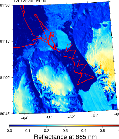
Petermann Glacier, Fjord, and Ice Island as seen by MODIS at 865 nm on Aug. 07, 2012 overlaid with survey lines of CCGS Henry Larsen on Aug.-9/10/11, 2012 in red.

We were not funded to do enter the fjord, but our main mission to recover an array of ocean moorings with 3-year long data records covering the 2009-12 period about 100 km to the south in Nares Strait has already been accomplished. So, what does a physical oceanographer do when in uncharted and unknown territory? He drops a number of CTDs, that is, measuring conductivity (C), temperature (T), and depth (D, pressure, really) as the instrument (the CTD) is lowered at a constant rate from the surface to the bottom of the ocean at a number of stations. The results from such work next to the present front of Petermann Glacier was a surprise for which we do not yet have a satisfactory explanation: The waters inside the fjord are much warmer at salinities 32.5-34.25 than they are outside the fjord:

Temperature as a function of salinity from 9 stations across Petermann Fjord next to the current seaward edge of Petermann Glacier on Aug.-10, 2012 in red. For comparison I show in blue a station done outside the fjord on Aug.-9, 2012. Note that temperatures increase with increasing salinity which is expected for waters that are a mixture of cold and fresh polar and saltier and warmer Atlantic waters. Density deviations from 1000 kg/m^3 are shown as solid contours along with the freezing temperature that decreases with increasing salinity.

Another way to show the same data is to actually plot the section, that is, the distribution of temperature and salinity in physical space across the fjord as a function of depth:

Section across the seaward edge Petermann Glacier on Aug.-10, 2012 for salinity (left panel) and temperature (right panel). Symbols indicate station locations from which color contours are drawn. Note that the display is cropped to the top 300 meters while real recordings extend to the bottom which exceeds 1000 meters. The view is eastward towards the glacier with north to the left.

Note the doming salinity contours which to classically trained oceanographers suggest a flow out of the page on the right and into the page on left with maximum at about 90 meter depth relative to no flow at, say, 500 meter depth. Another way to view this distinct property distribution is that the flow above 90 meters is clockwise (outflow on left, inflow on right) relative to the more counter-clockwise flow below this depth. This feature, too, comes as a surprise and requires more thought and analyses to explain.

There is much more work to be done to figure out what all this means. I feel like scratching the surface of a large iceberg half-blind. The data from below 300 meter depth, too, contain clues on how some this glacier interacts with the ocean. As for the purpose of this post, I merely wanted to report that the ice island is presently having a hitting or scratching tiny Hans Island. The latter is unlikely to move, but Petermann’s Ice Island will slow on impact, swivel counter-clockwise, bump into Ellesmere, and pretend nothing has happened on its merry way south. This is the latest image I have:

Petermann Ice Island 2012 on Aug.-22, 2012 as seen by MODIS Terra at 21:45 UTC. The tiny red dot marks Hans Island, the location of a weather station in the Kennedy Channel section of Nares Strait. Petermann Fjord is towards the top right out of view.

ADDENDUM Sept.-1, 2012: PII-2010B had a maximum thickness of at least 144 meters as it passed over a mooring that measures ocean currents from the Doppler shift of acoustic backscatter that is shown here for one of four beams:
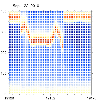
Time-depth series of acoustic scatter from a bottom-mounted acoustic Doppler current profiler for 24 hours starting Sept-22, 2010 9:30 UTC. Red colors indicate high backscatter from a “hard” surface like ice. The vertical axis depth in meters above the transducers while the horizontal is ensemble number into the record (0.5 hours between ensembles). The 2010 ice island from Petermann Glacier (PII-2010B) passed over the mooring. When PII-2010B was attached to the glacier it was adjacent to the segment that became PII-2012 this year.