
Scientists like myself always have ideas and theories on how oceans and climate work, but these need testing with real (not virtual) data before they can be accepted as truth or dismissed as fool’s errand. This is how science works. And today the National Science Foundation recommended that funds are made available for me to work with German scientists of the Alfred Wegener Institute to test some of our ideas with direct ocean current and temperature measurements. Together we will explore how heat from the deep Atlantic Ocean moves towards Nioghalvfjerdsfjorden Gletscher (often also called 79N Glacier) and Zachariae Isstrom. These are two of the largest glaciers in Greenland, both have floating ice shelves, and both are in some of the most remote and least explored coastal areas of Greenland.
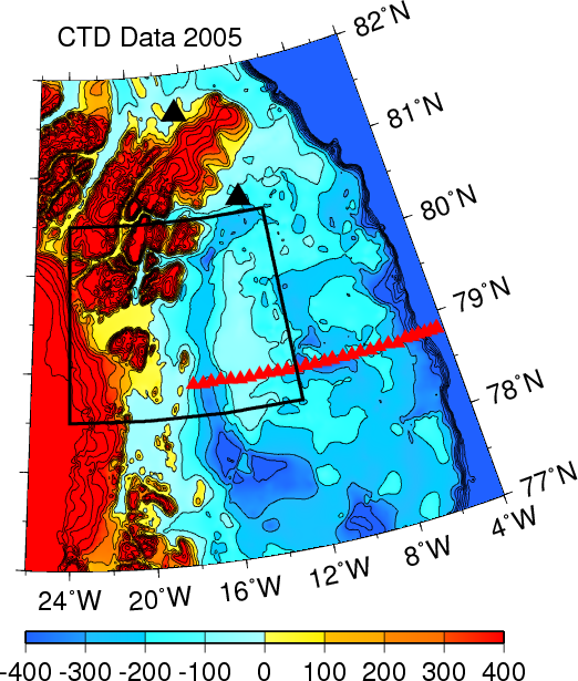
North-East Greenland continental shelf with 2005 CTD stations (red triangles). Yellow contours are floating ice shelves, black triangles are weather stations, the black box is the frame of the MODIS satellite imagery.
Greenland’s tidewater glaciers are losing mass at an increasing rate. Warm ocean waters of Atlantic origin are a main source of heat for melting these glaciers from below. While the exact contributions and details of ocean melting vary from glacier to glacier, little doubt exists that the ocean’s heat and currents contribute to retreating glaciers. And yet, nobody really knows how the heat from the deep Atlantic Ocean 1. crosses shallow and broad continental shelves to 2. enter the coastal fjords, and to 3. reach the glaciers. The maps show glaciers in the left, deep ocean on the right, and partly ice-covered shallow continental shelves in the middle off North-East Greenland.
Our provisional idea is that a 20-km wide channel facilitates movement of warm Atlantic waters across the shelf towards coastal glaciers and ice shelves. More specifically, we want to find out if warm Atlantic water crosses the NE Greenland shelf as a bottom-intensified flow off Norske Oer Trough towards 79N and Zachariae Glaciers. Furthermore, I speculate that variable ice cover does not influence this postulated current of Atlantic waters towards the glaciers, but that a physical process involving tidal currents near Belgica Bank does.
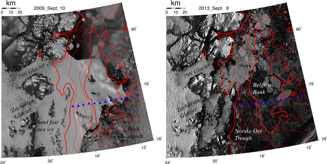
Visible MODIS imagery of the study area at 250 m resolution showing 79N and Zachariae, Glaciers, Norske Ore Trough, and Belgica Bank for Sept.-2009 (left) and Sept.-2013 (right). Mountains are naturally illuminated by low sun angles. Red contours are 100, 200, and 300 m bottom depths. Blue symbols show 2002 and 2005 science stations.
The above statements are provisional ideas (or hypotheses) to be tested with analyses of moored and satellite observations, diagnostic modeling, and synoptic ship-based surveys of water temperature, salinity, density, and currents. As the ocean is forced by physics at the ice-water, air-water, and ice-air interfaces, our study also includes data from a meteorological station as well as satellite observations to investigate sea ice.
![R/V Polarstern in icy seas Eismeer [Photo Credit: Alfred Wegener Institute, Germany]](https://icyseas.org/wp-content/uploads/2013/10/luftaufnahme_p.jpg)
R/V Polarstern in icy seas.[Photo Credit: Alfred Wegener Institute, Germany]
Earlier this year I was dreaming about such a study when writing about “Travels-by-Mind.” This was the first or second step in what now will become real because the funds from the NSF will allow me to build instruments, buy batteries, and travel to board the German research icebreaker R/V Polarstern next year. A group of scientists from Germany, Norway, Canada, and the US will work together to uncover how warm ocean water 200-300 meters below the surface approach two of the largest glaciers of Greenland.
I am humbled by and most grateful to American and German tax payers who make this work possible by paying for these studies. I will shared data, science, and excitement with everyone on these and other pages.
Budéus, G., & Schneider, W. (1995). On the hydrography of the Northeast Water Polynya Journal of Geophysical Research, 100 (C3) DOI: 10.1029/94JC02024
Hughes, N., Wilkinson, J., & Wadhams, P. (2011). Multi-satellite sensor analysis of fast-ice development in the Norske Øer Ice Barrier, northeast Greenland Annals of Glaciology, 52 (57), 151-160 DOI: 10.3189/172756411795931633
Reeh, N., Thomsen, H., Higgins, A., & Weidick, A. (2001). Sea ice and the stability of north and northeast Greenland floating glaciers Annals of Glaciology, 33 (1), 474-480 DOI: 10.3189/172756401781818554
Wadhams, P., Wilkinson, J., & McPhail, S. (2006). A new view of the underside of Arctic sea ice Geophysical Research Letters, 33 (4) DOI: 10.1029/2005GL025131


Excellent, Andreas. This will be tax payer money well spent.
I didn’t quite follow what has been going on in the 79N and Zachariae region this melting season, but I believe Espen did make many contributions on the Arctic Sea Ice Forum. There wasn’t much ice transport along the eastern Greenland coast, and a lot of fast ice seemed to be breaking off near these two glaciers, if I remember correctly (and seems to be confirmed by the MODIS imagery you posted). Did something interesting happen there from a historical perspective this year, or was it all just the regular back and forth?
Neven:
The writing of this proposal is not related to anything new happening in this area. It more closely relates to story lines on how oceans impact ice shelves off both Greenland and Antarctica. This is an evolving research theme for the last 5 years or more. Petermann Glacier falls into the same category as does Pine Island and Jacobshavn. Looking at 1979-present SSM/I data, I see no significant change of sea-ice cover in September, however, for the month of May there is a significant decrease which probably relates to changing land-fast ice cover:
In past decades rafted multi-year ice and tabular icebergs often grounded over shallow Belgica Bank and thus provided an anchor to maintain stability for a year-round land-fast ice cover called the Norske Oer Ice Barrier (NOIB). The area to the north of NOIB features the North-East Water (NEW) polynya, an area of thin ice and open water from March through September (Schneider et al., 1995) with attendant high biological activity (Smith et al., 1995). The NOIB disintegrated in 2003 (Hughes et al., 2011) and has become an intermittent rather than a regular feature. Barber and Masson (2007) state that
“… the NEW polynya has ceased to exist due to a non-occurence of the ice bridge at its northern end (Minnett, pers. comm.). The reasons for this change are currently unknown …”
This proposal/project will not focus on polynyas, but I posit, that this continental shelf, its circulation, and interaction with adjacent glaciers and ice shelves are all in transition.
Wonderful news, indeed! I’m glad that some of my tax dollars are going towards worthwhile scientific endeavors.
Well, you are even doing more than that …
Congratulations, Andreas. it is probably one of the most interesting areas of Ice-Greenland, the huge retreat of Zachariae Isstrøm over the last couple of years, is worth a serious study. Another interesting spot is NOIB, will it ever show up again, all of its fast ice took of this season.
Nobody knows, but the quote above in response to Neven’s comment perhaps gives one possible answer.
While I do sincerely applaud your ongoing commitment to gain further knowledge of the mechanisms involved, I have to return to the point I have made previously; that the warm water may be the result of the kinetic heating of glacial melt water from a very high water column. Taking your illustration CTD Data 2005, behind the two glaciers, to the left of the illustration, is topography, six further orders of magnitude above the 400 metre mark in an obvious steep slope.
To convince me, you are going to have to, at one and the same time, log the sub glacial melt flows and show that they are entirely separate to the warm oceanic waters you are observing.
Good luck.
Agreed, but such a study will break the bank. Furthermore, how much of this potential heat energy will be used up carving melt-channels and bed-rock as it descends from high altitude towards the ocean? Put another way, how much of this heat is dissipated before it reaches the ocean?
Nice work, this is a much needed gap in our understanding. Great baseline too, what will happen after these great glaciers have retreated more notably?
I believe (=I do not know) that a new equilibrium will eventually be reached that includes a globally higher sea level, because some ice that presently sits on land floats out into the ocean where it will melt. There will be feedbacks, both positive and negative, that are not entirely clear. There exist more than one possible climate scenario, some of which will be less favorable than others according to (imperfect) climate simulations.
Hi Andreas,
I am at a loss to explain the very high occurence of melt this year in the NE of Greenland, as seen here…
http://nsidc.org/greenland-today/
Pingback: First Research Mission for Norway’s new Icebreaker | Icy Seas
If Fram was a river current heading south and the Belgica Bank was a sandbar I’d expect my canoe to float north through Norske Oer Trough at a rate determined by the velocity of the current at Fram.
If Warm Atlantic Water were forced into the eddy the shoaling bottom might force it higher in the water column until it was interacting with fast ice &or subglacial currents pressing it against the ice front.
I’m aware this is a gross simplification that ignores everything from Ekman Transport to thermohaline conditions, but is there evidence of changes to Fram’s southern velocity that might have an effect on the gyre?
Terry
@Terry:
This is exactly the kind of evidence that we are looking for. The Germans and Norwegians have maintained a ocean observing array in the deeper waters of Fram Strait for more than a decade, but this new array on the shelf towards Belgica Bank is new. So, nobody knows the answer to your question, but we are hoping to say something whe then data are coming back.
Pingback: Fram Strait Ice, Oil, and Glaciers | Icy Seas