
The ice of the Arctic Ocean is rapidly disappearing. This happens every summer, but for the last 30 years there is a little less ice left at the end of each summer than there was the year before. The areas covered by ice are not only shrinking, the ice is also getting thinner, or so many do believe.
To check out such claims, we placed sound systems on the ocean floor of Nares Strait from which to find out how much the thickness of the ice above has changed. We started this in 2003, were told to stop it in 2009, but privately parked our instruments where they would collect data. We must get to check our sound systems and retrieve the private recordings, because otherwise Poseidon will claim our possessions for parking violations. The Canadian Coast Guard Ship Henry Larsen, we hope, will help us to negotiate water and ice to get us deep into Nares Strait as she and her crew did so well in 2006, 2007, and last in 2009.

CCGS Henry Larsen in thick and multi-year ice of Nares Strait in August 2009. View is to the south with Greenland in the background. [Photo Credit: Dr. Helen Johnson]

The ice profiling sonar sounds system before its first deployment in Nares Strait in August 2003 from aboard the USCGC Healy. It measure ice thickness many times each seconds for up to 3 years. View is to the north-west with Ellesmere Island, Canada in the background. Listening in are Jay Simpkins (left), Helen Johnson, and Peter Gamble.
Nares Strait to the west of northern Greenland is one of two major gates for the thickest, the hardest, and the oldest ice to leave the Arctic for the Atlantic Ocean [Fram Strait to the east of Greenland is the other.] This gate is closed at the moment by an arching ice bridge that locks all ice in place. No ice can leave the Arctic via Nares Strait as long as these arches hold. The ice arch acts as a dam that holds back the flood of ice that will come streaming south hard once the dam breaks. And break it will, usually between the end of June and July.

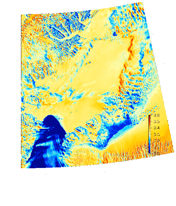
Ice arch in southern Nares Strait as seen by MODIS Terra on June-18, 2012. Greenland is on the right, Canada on the left. The dark blue colors in the bottom-left are open water, yellow are the ice caps of Greenland and Ellesmere Island and lighter shades of blue are warm ice or land. Humboldt Glacier is the on the right-center where Nares Strait is at its widest with Kane Basin at about 80 N latitude.

Nares Strait Jun.-10, 2012 image showing land-fast ice between northern Greenland and Canada as well as the ice arch in the south (bottom left) separating sea ice from open water (North Water). The coastline is indicated as the black line.
The sooner it breaks, the more old ice the Arctic will lose and the better it is for us to get an icebreaker to where must be to recover our instruments and data. The data will tell us if the ice has changed the last 9 years.
I processed and archived maps of Nares Strait satellite images to guide 2003-2012 analyses of how air, water, and ice change from day to day. Ice arches formed as expected during the 2003/04, 2004/05, and 2005/06 winters lasting for about 180-230 days each year. In 2006/07 no ice arch formed, ice streamed freely southward all year, and this certainly contributed to the 2007 record low ice cover. In 2007/08 the arch was in place for only 65 days. In 2009/10, 2010/11, and now 2011/12 ice cover appear normal as the arches formed in December and lasted until July.
We live in exciting times of dramatic change, some to the better and some to the worse. Some of the change is caused by global warming while most is probably not. We do not know for sure, but most of the evidence points towards us people as a major driver of the change we observe in the Arctic and elsewhere. Nevertheless, climate and its change is one grand puzzle that no single scientist, no single discipline, no single country, and no single continent can solve. There are many pieces that all contribute to how and why the Arctic ice changes the way it does. And this includes the ice arches of Nares Strait. There are many mysteries and unresolved physics in what makes these ice arches tick and what makes them blow to bits, but blow they will … watch it, it’s fun, and perfectly natural.
EDIT: This movie shows just how stable the ice arch is at the moment.


I had a feeling this year’s ice arch in Nares Strait wasn’t as solid as last year’s, basing myself on ENVISAT radar images, and the fact that last year there were some very low air temperatures in the region (I believe it was less cold this year). But last year’s ice arch broke up on June 17th, so I guess this year’s ice arch is more solid.
Looking forward to your next posts.
Neven: Thank you for the compliments. Most of my data collection, processing, analyses are funded by U.S. tax payers (via the National Science Foundation), so, these are the people really responsible … also, thank you for spreading the word, all data, graphics, and codes reside in the public domain 😉
First – thanks for providing the site.
I’ve read what I could find about Nares & had been struck by findings that the currents run in both directions simultaneously. I’ve speculated that when air pressure differentials between the ends is large, the flow under the ice would increase, flowing to the lower pressure area. I believe something similar occurs in Lake Erie, but think that the narrowness an funneling at Nares channel would enhance the effect.
I’m aware that flow rates vary hugely, and that the warmer, northerly flow is much smaller than the southerly. The effect I’m postulating may be lost in the noise – or it may exist only in my imaginings.
I wonder if any of your studies have seen evidence of such a phenomena?
A New Daily Lurker (and occasional poster)
Terry
Terry: It all depends on a delicate balance of forces. The pressure gradients in the atmosphere causes winds which, if exposed to mobile ice or water, exert a stress that accelerates the water or ice. And for much of the larger-scale circulation of air (winds) and water (currents) one needs to consider the effects of the earth’s rotation. The flow around a high pressure system is AROUND this pressure system due to the so-called “Coriolis force” (earth’s rotation). In a density stratified flow as the ocean in Nares Strait (fresher at surface, saltier below) the scale is about 5-10 km (3-6 miles) at which these additional rotational forces play a role. Thus it makes perfect sense to me to have opposing flows both vertically and horizontally in Nares Strait that are little effected by winds or pressures in the atmosphere. In good fun … Publication on this.
Andreas – I’d skimmed your Paper in the past and am now attempting to groc it. I’d also read of the gale force winds you experienced at Nares (I assume that was your group), and will read that post again.
The opening in Robeson Channel on the 19th (started from the Canadian side on the 18th) seems to me to be a response to spring tide, as well as a high pressure system to the south. The ice appears to be fractured around the polynya at the north of Kane Basin also.
I know from your paper that deep currents are apparently not affected by pressure differentials or wind, but the upper 30M with the ice cover does seem to react (at least to my eye).
I’ve got some questions re. your paper, but want to spend more time with it to see if I can’t resolve them myself. My health is a little iffy at the moment so please forgive any lag time in responding.
Terry
BTW – Best book review I’ve read in a while – I want a set of his boots!
Pingback: Ocean heat flux and the Arctic
Pingback: Ocean Heat Flux - After Gutenberg
Pingback: The currents and winds of Nares Strait | Icy Seas
Pingback: Reblog: The currents and winds of Nares Strait | Allison E. Einolf