Adaptations of Genetically Isolated Polar Bears in Southeast Greenland

Ms. Amanda Winton wrote this essay as an extra-curricular activity developed from a science communication assignment for MAST383 – Introduction to Ocean Sciences. The editor teaches this course at the University of Delaware and was assisted by Ms. Terri Gillespie in a final formal edit. ~Editor

“… The intense winds blow against my white fur. The chunks of white, frosty glacial ice float below me. I lift my eyes, scanning my surroundings for my next meal. I see a dark gray mass sliding along the ice a few hundred feet away. My mouth waters as my paws ready for the hunt. I have not eaten, nor seen any prey, in 12 days. I begin my slow and steady pursuit. The terrain below me is rough, unlike the abundant flat sea ice that was my ancestors’ hunting grounds.

It is a little bit more difficult to maneuver, taking more time to get to my prey than I would have hoped. Minutes later, I jump into the water, about to swim to the ice my prey is lounging on. Unfortunately, I grossly underestimated how far away it is, and by the time I swim to this meal, it’s gone. Now I am left with no food, and my stomach grumbles for the fifth time today.”

This short, first-person narrative is written from the perspective of a Greenland polar bear in the summertime. In particular, this polar bear is part of a subpopulation that hunts on a glacial mélange within fjords, rather than on larger frozen ice caps. Of course, I do not know what polar bears think in their pursuits, migration, or other actions. I can only use my own experiences and compassion to imagine their point of view and desires. Based on my biocentric view, all animals have their own importance in the world and are worthy of preservation. Since human intervention causes polar bears to struggle in their own environment, people have the responsibility to save them and recover their habitat.

Figure 1. This depicts the types of glaciers that can be present in different places, depending on the snow and ice available as well as the pressure and heat present. [adapted from National Snow and Ice Data Center]

Polar bears are losing their land due to the indirect and direct effects of human interaction with the environment, called climate change. Atmospheric warming leads to scarce and thinner glaciers, as well as less advancement in the growth season. The breakup of ice in the spring due to melting occurs nine days earlier than it did before global warming was identified in 1938 (Maslin, 2016), and the freezing of ice in the fall occurs ten days later (EPA, 2022). Not only is there less ice, but the ice exists for a shorter period of time. This leads to less territory, which can be detrimental to any species.

When Glacier National Park in Montana was established in 1910, about 150 glaciers existed. Now, less than 30 remain (Glick, 2021). Polar bears are forced to look for land and food elsewhere because they do not have as much space to hunt and breed. There is not much land or food present, so the natural selection rate for this animal is increasing dramatically every day, at a rate as fast as climate change (Peacock, 2022). Polar bears are forced by their environment to either die or adapt. This is not an easy adaptation, either.

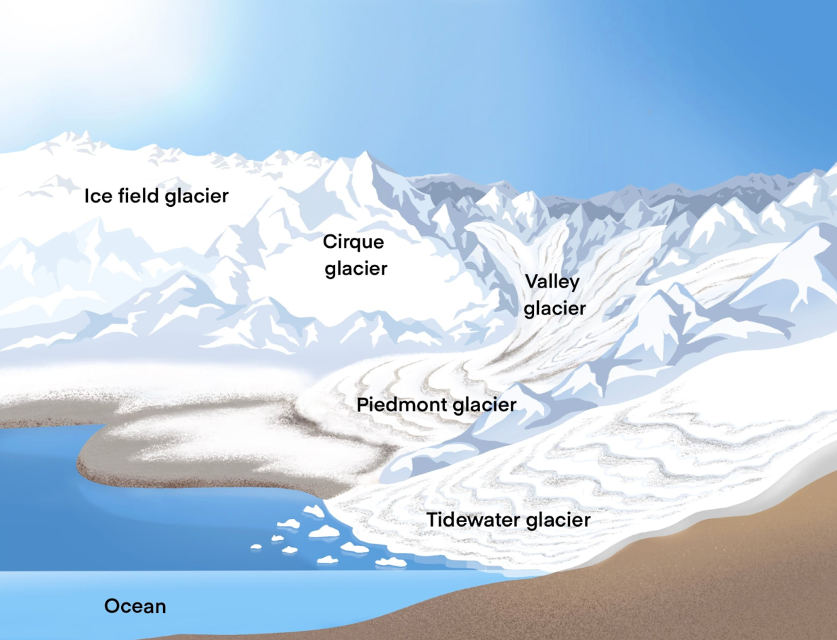
Polar bears are forced to adapt quickly, since glacier ice is very limited in the Arctic. On the southeast coast of Greenland, polar bears have implemented a new habitat: fjords. These bears live at the front of glaciers in fjords, called the glacial mélange, which is a mixture of sea ice, icebergs, and snow. Only polar bears in southeast Greenland live there all year round, using this habitat to breed, hunt, and sleep.

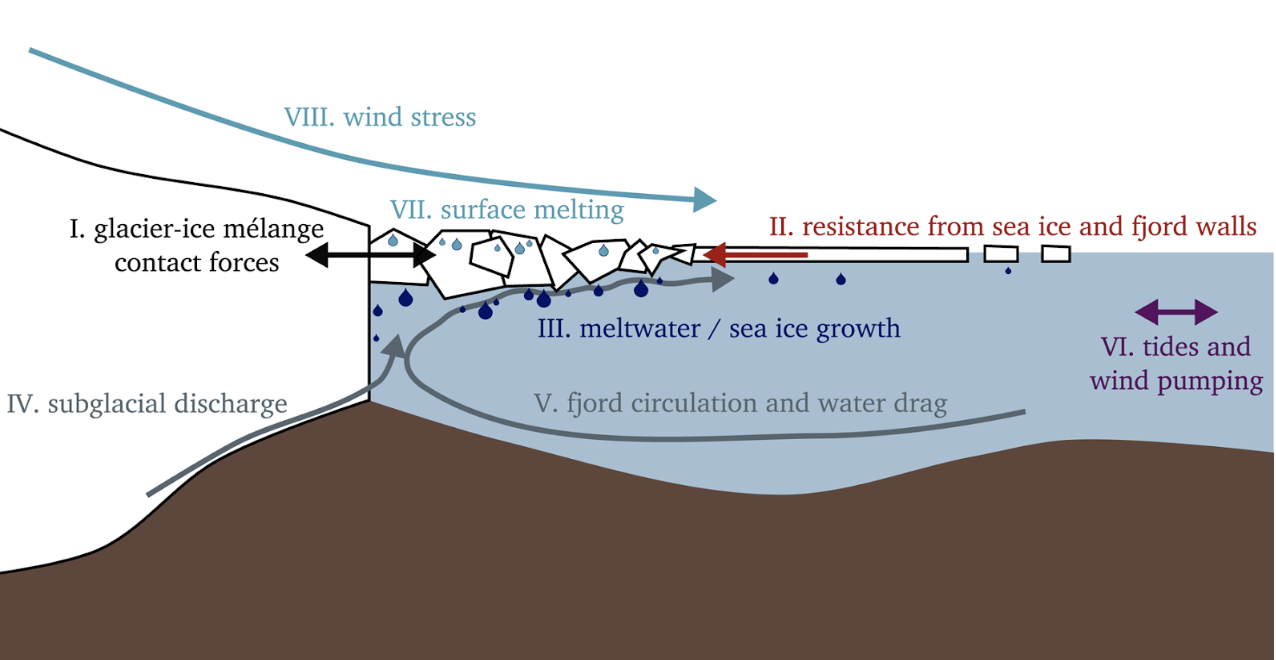
Figure 2. This Glacier-Ocean-Mélange System depicts the forces acting upon this mechanism at all times. These forces are important for keeping the system at equilibrium and habitable for polar bears. [adapted from Amundson et al. (2020)]

In a recent research study led by Kristin Laidre, Northeast and Southeast Greenland polar bear population migrations were tracked. The median distance of the polar bears in the northeast was 40km per four days. The median distance traveled for the southeast population was 10km per four days, which is statistically significantly lower. Laidre et al. (2022) found that the southeast polar bears traveled between neighboring fjords, or stayed in the same fjord all year. This adaptation shows behavioral plasticity (Peacock, 2022), as Southeast Greenland bears have not become locally extinct.

This subpopulation of polar bears is one out of 20, and is very small. They are smaller in size and have a slower reproduction rate, most likely due to trouble finding a mate in a small population, as well as their long generation time and low natality. It’s important to preserve this genetically isolated population to preserve their genetic diversity. Without this element, birth defects, either mental or physical, will occur. This leads to a population less fit for its environment. Genetic diversity is necessary for surviving natural selection and thriving in an ecosystem. 

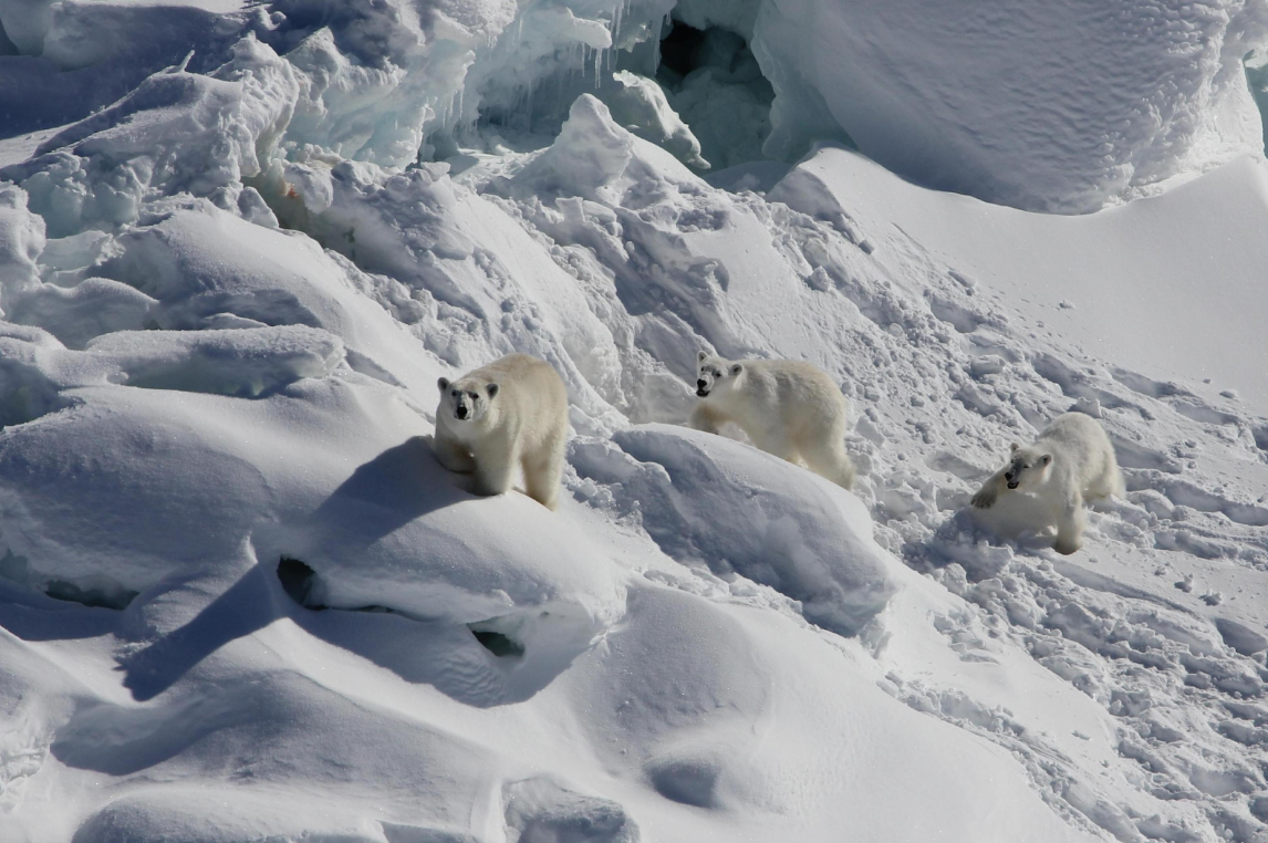
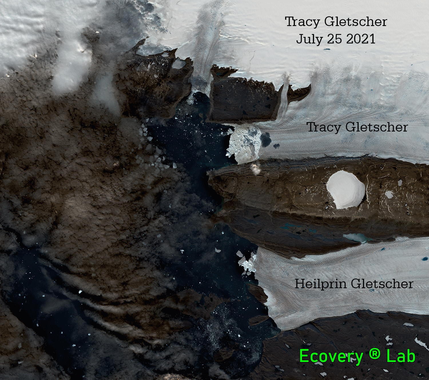
Figure 3. This photograph presents polar bears walking in the snowy fjords. Fjords are not flat, which makes it harder for these bears to travel, versus the flat ice that other polar bears have been hunting on for centuries. [adapted from Laidre et al. 2022]

“… I leave my fjord the next day, hoping to find another nearby, hopefully unoccupied. To my luck, one appears in my field of vision a few hundred meters away. To my surprise, a bob of seals rests on the glacial mélange. They are oblivious and unsuspecting of my presence. Minutes pass, and my stomach no longer rumbles. A successful hunt is always satisfactory. Now I can focus on my next need: my desire to find a mate and pass on my strong genes. It will not be too hard for me as I am a big male, with thick, insulated fur. I advance through the neighboring fjord, hopeful and confident. My story is just beginning.”

References:

Amundson, J., Kienholz, C., Hager, A., Jackson, R., Motyka, R., Nash, J., Sutherland, D., 2020: Formation, flow and break-up of ephemeral ice mélange at LeConte Glacier and Bay, Alaska. Journal of Glaciology, 66(258), 577-590. doi:10.1017/jog.2020.29.

Environmental Protection Agency, 2022: Climate Change Indicators: Arctic Sea Ice, https://www.epa.gov/climate-indicators/climate-change-indicators-arctic-sea-ice.

Dunham, W., 2022: Isolated Greenland Polar Bear Population Adapts to Climate Change. Reuters, Thomson Reuters, https://www.reuters.com/business/environment/isolated-greenland-polar-bear-population-adapts-climate-change-2022-06-16.

Glick, D., 2021: The Big Thaw. National Geographic, https://www.nationalgeographic.com/environment/article/big-thaw.

Greenfieldboyce, N., 2022: In a Place with Little Sea Ice, Polar Bears Have Found Another Way to Hunt, KTOO, https://www.ktoo.org/2022/06/20/in-a-place-with-little-sea-ice-polar-bears-have-found-another-way-to-hunt/.

Laidre, K. L. and 18 others, 2022: Glacial Ice Supports a Distinct and Undocumented Polar Bear Subpopulation Persisting in Late 21st-Century Sea-Ice Conditions, vol. 376(6599), 1333–1338, https://doi.org/10.1126/science.abk2793.

Maslin, M. , 2016: Forty years of linking orbits to ice ages, Nature, 540, 208–209, https://doi.org/10.1038/540208a.

Ogasa, N., 2022: Some Polar Bears in Greenland Survive on Surprisingly Little Sea Ice, Science News, https://www.sciencenews.org/article/polar-bear-greeland-sea-ice-glacial-melange-climate-change.

Peacock, E., 2022: A new polar bear Population, Science, vol. 376(6599), 1267–1268, https://doi.org/10.1126/science.abq5267.

National Snow and Ice Data Center, 2022: Glaciers, https://nsidc.org/learn/parts-cryosphere/glaciers/science-glaciers.

My own private Iceland

Reading Halldor Laxness’ epic novel “Independent People,” I am in Iceland for the last 10 days. I re-discovered this author after reading a small essay the New Yorker published last week. This book is set in Iceland of the early 1900s to the mid 1920ies. Sheep, starvation, and spirits evil and otherwise all play roles as does time that changes people, politics, and procreation. Finishing it sunday, I feel I have been here before.

Lifted from fioncchu,blogspot.com

My first Laxness novel “Islandklukken” (Iceland’s Bell in English) I read as a 20-year old during the Cold War when I served my country for 16 month more than 40 years ago. At the time I dreamt of the world as it had not yet revealed itself to me. My pre-college mind had a romantic notion of walking remote and wild areas of Norway and Iceland after an unromantic 1981 motorcycle trip across southern Norway the prior summer. I now worked as a paramedic in the drizzly gray German town of Husum by the North Sea. During this first winter away from parents and High School friends I bought my first Laxness and immediate afterwards “Die Saga von Egil” (Egil Skallagrimsson Saga). This Icelandic saga was written about 1200 AD and it chronicles the life of a viking poet farmer who killed many men for the 91 years after his birth in 904 AD. Along with this book I also bought a topographic map of Iceland published by the Touring Club of Iceland at a scale of 1:750,000 printed in 1979 in Reykjavik. It cost me 29.90 Deutsche Mark or about 10% of my monthly income at the time. Such armed, I followed Egil Skallagrimsson across Iceland starting at his place of birth about 35 miles north of Reykjavik.


Oil on canvas: “Summer in the Greenland coast circa the year 1000” painted by Danish painter Carl Rasmussen in 1874.

The same map follows me on my current travels across Iceland until I find the many databases of the Icelandic Geodedic Survey. High-resolution (1:50,000 scale, say) are generated instantly whereever I want. For days now I am hiking for days across the Icelandic highlands in the East and West, across interior deserts in the center, and wet coasts in the North. My first trip was across the Highlands from Pingvellir to Reykir past the glacier Langjoekull to the North and West and the glacier Hofsjoekull in the East and South. My maps locate many backcountry huts where I stay or pitch my tent. I here follow Dieter Graser’s excellent descriptions, photos, and GPS waypoints when he hiked the “Kjalvegur” alone in 2007. I even stole this map from his content-rich web-site where I spent the last 2 days traveling with finger on maps, books, and internets

Dieter Graser’s hike from Pingvellir in the south-west to Maellfell near Reykir in the north-east. It took him 19 days to complete this hike in August of 2007. [Credit Dieter Graser]

I even got a first intinary: My direct Iceland Air flight leaves Baltimore on Aug.-16 at 8:30 pm in the evening and arrives in Reykjavik the next morning at 6:25 am. A Grey Line bus gets me into the Highland for less than $48 in 2 1/2 hours, but it does not leave until 8 am on the next day. Hence there is plenty of time in iceland’s capital city to explore, get provisions, and perhaps visit the Landsbjoerg which is Iceland’s Search and Rescue organization. It is good practice to let someone local know when you will be where and back as one heads into the backcountry. The bus will let me off in Hviternes from where it is a 40 km hike to Hveravellir where there are two web-cams: the first points to the West while the second points East. I got 5 days to do this 3-day hike, so there is time for a day or two to do nothing, read, or just soak in the scenery and/or a hot spring and/or both at the same time. The bus will pick me up at the hot springs of Hveravellir at 2:30 pm on Aug.-22 to get me back to Reykjavik at 7:30 pm which is plenty of time to catch my plane back home the next day at 5:10 pm with an arrival 6 hours later. The return flight comes to $746 and even includes my backpack (<50 lbs).

There is just one problem … my passport expired.

P.S.: The three photos below are all from Dieter Graser who shared them at his outstanding web-site at http://www.isafold.de/

The hut Þverbrekknamúli along the “Kjalvegur.” The view is to the east with the Kerlingarfjöll in the back. [Credit Dieter Graser]
Dieter Graser at Hvítárnes in 2007. [Credit Dieter Graser].
Hveravellir in August 2007. [Credit Dieter Graser]

Ice, ocean, and glacier change in northern Greenland

Steffen Olsen is a Danish physical oceanographer with a skill to present beauty to an artist like my wife and a scientist like me. Three days ago he posted a photo on Twitter with these words

Local hunters from Qaanaaq navigating our CTD system in the frozen ice mélange in front of Tracy Galcier 66W 77N to measure the ocean below. Heat loss to melting of glacial ice leaves the ocean at sub-zero temperatures down to 400m @arctic_passion @dmidk @ruth_mottram

Photo: Dogsled from Qaanaaq near the northern edge of Tracy Gletscher in Inglefield Fjord April 2022. [Credit: Dr. Steffen Olsen, Danish Meteorological Institute.]

Steffen’s photo shows his study area, research platform, and mode of transportation. There is a glacier in the background between the rocks on the left (north) and unseen mountains to the right (south). Equally unseen is the ocean under all this crushed and broken and piled up sea ice covered by fresh snow. We see tracks of people walking to the vantage point from where the photo is taken. The dogs rest on a small patch of level sea ice perhaps 3-5 feet (1 to 1.5 meters) thick.

There are boxes on the sled that contain gear to drill through the sea ice and then to send a probe down towards the ocean bottom to measure ocean temperature, saltiness, and oxygen during its decent. I did similar work with a snowmobile in 2017 based at Thule Air Base for 6 weeks. Steffen and I work together on such data. He collected these every year since 2011 both adjacent to Tracy Gletscher and along most of the ~120 km long and ~1000 meter deep fjord. I am grateful to Steffen to share this photo: It helps me to focus on my passions rather than my outrage at soldiers and leaders of the Russian Federation in their war to destroy Ukraine and its people building a free, vibrant, and democratic country for themselves. There is more, but I stop here now.

Let me start with a map of where in Greenland the photo was taken and where Steffen collected his data each since 2011. The red star in the insert top-right shows the location of the map between Canada and Greenland. I color ocean bottom depths in blue shades and land heights in green, yellow, and brown shades. The glacier in Steffen’s photo is at the north-eastern end of Inglefield Fjord where I placed the label Tracy. The label Qaanaaq shows where about 650 Inughuit live along the coast near the center of the fjord. It probaby took the dogs about 2-3 days to travel with their cargo from Qaanaaq to Tracy Gletscher. Red dots are stations served by a Danish Navy ship in the summer of 2015, but I here only talk about the blue dots.

Figure: Map of the study area with ocean sampling stations in Inglefield Fjord (blue dots) and adjacent northern Baffin Bay. [Unpublished own work.]

The blue dots are stations where Steffen and his companions drilled through the sea ice in 2018. Note that some of those ocean stations appear on land. This cannot be, but the glacier has retreated between the time the topographic data was collected and 2018 when Steffen collected the ocean data. Three LandSat satellite images below show how the glacier changed from 1973 to July and August of 2021. Icebergs are visible, too. A citizen scientist with the handle “Espen” at the Arctic Sea Ice Forum extracted these satellite photos from public U.S. databases. He is part of an online international community of Greenland and sea ice enthusiasts who posts at this forum for over a decade making daily discovers. These are people with regular jobs that in their spare time post satellite imagery and open data they found which they share openly often with insightful interpretations. It is citizen science at its very best. I go there often to read, ask, and learn. I even met a prominent member once for lunch when visiting Copenhagen on my way to Greenland. He gifted me LandSat imagery of my favorite glaciers printed on cloth that I framed for its scientific and artistic beauty. Thank you, Espen 😉

Gallery: Space photography (LandSat) of glaciers terminating from the Greenland ice sheet in Inglefield Fjord in 1973 (right), July 2021 (center), and August 2021 showing the retreat of Tracy but not Heilprin Gletscher. [Credit: Espen Olsen at Arctic Sea Ice Forum.]

So how does the ocean below all this ice next to a glacier look? Well, lets look at a set of station from Qaanaaq to Tracy Gletscher that shows how temperature, salinity, and oxygen of the water changes both with depth and along the fjord. We always find very cold, somewhat fresher, and highly oxygenated water near the ocean surface about 40 m (near glacier) to 100 m (near Qaanaaq) below the sea ice and warmer, saltier, and less oxygenated water below with a temperature maximum of 1 degree Celsius near 300 m depth. It is this warm water that melts the adjacent glacier. As Dr. Olsen says “… Heat loss to melting of glacial ice leaves the ocean at sub-zero temperatures …” In other words, the deeper waters 1. enter the fjord at temperatures above zero degrees Centigrade, 2. reach the glacier, 3. cool down as they melt the glacier, and 4. leave the fjord at temperatures below zero degrees Centigrade. This is why the two stations near the glacier show slightly fresher and cooler waters between 300 and 500 m depth. This water contains the glacial melt. The section represents the 10 year average from 2011 through 2020.

Figure: Section of salinity (bottom), temperature (center), and dissolved oxygen (top) along Inglefield Fjord as an average of data collected annually between 2011 and 2020. [Unpublished own work.]

Earlier this year I tried to visit Copenhagen to finish this work that places this emerging story into both a historical and spatial context, but Covid restrictions derailed this and other plans. Nevertheless, have excellent data from 1928 when this fjord was first surveyed by Danish oceanographers. At that time the waters had dramatically different temperatures (much colder) and salinities (a little fresher) both inside the fjord and in Baffin Bay adjacent to it. The changes are probably related to a much changed sea ice cover and perhaps ocean circulation that relates how the winds impact the ocean with and without sea ice. For the 1979 to present satellite record, we can quantify how much sea ice covers both the fjord and adjacent ocean. I made the graph below last week from 14073 almost daily satellite images whose data the U.S. National Snow and Ice Data Center distributes freely. I show annual averages for each of the 42 years that these SSM/I satellites have been measuring sea areal coverage from space.

Figure: Annual averages of sea ice cover 1979 through 2021 with linear trend lines for two 21-year subsets (blue) and the entire 42-year record (red). [Unpublished own work.]

Before the year 2000 the sea ice cover fluctuated between 26,000 and 39,000 km2 and if one for how these changes are trending between 1979 and 2002, one finds a slight increase in the blue line, however, this increase is not significantly different from zero at a high 95% level of confidence. For the second period after 2002, the ice covered area fluctuates much less, from about 22,000 to 28,000 km2 and the trend line in blue now indicates decreasing sea ice cover. As before, however, this blue trend line is no different from zero at the same high level of confidence. We also notice that there is a red trend line that I derive from using all 42 years of data. This line is very different and statistically significant, but it does not quiet do justice to the almost step-like change that appears to happen around 2000 through 2005. What happened then? I do not know, yet, but this is the fun of doing science: There is always more to discover. The sea ice cover in northern Greenland does not always follow a straight line. This is not different from our climate or life. Expect the unexpected, adjust, and keep moving. Or in Dr. Olsen’s words:

“… you have a number of years where conditions don’t follow the more linear track of (predicted) scenarios,” explained Dr. Olsen. “A warming tendency can be reversed for some years, for example.” [From https://phys.org, Oct.-13, 2021]

Waves Across the Pacific

Claudia Schreier is a sophomore at the University of Delaware. She majors in Chemical Engineering with a minor in Marine Sciences. Ms. Schreier’s essay emerged from an assignment in an undergraduate “Introduction to Ocean Science” class taught by Drs. K. Billups and A. Muenchow in the fall of 2020. ~A. Muenchow, Editor

The 1967 documentary “Waves Across the Pacific” highlights some of the first uses of high-tech measuring tools and novel techniques to discover how waves move across the Pacific Ocean. Dr. Walter Munk and his research team studied how wave energy from storms off Antarctica is lost as waves move across the equator towards Alaska. This was the first time that anyone collected and reported data for wave processes on a global scale.

Dr. Munk in 1963 (UC San Diego Library)

The vessel that the team used for this expedition was fascinating; it is called FLIP, and it is a mobile floating instrument platform standing 355 feet tall, providing both the space and stability for the laboratory and its equipment. Waves originating from Antarctica reached New Zealand, and then moved farther in every direction within the Pacific Ocean. Recording stations were located in New Zealand, Samoa, Palmyra (an uninhabited equatorial atoll), Hawaii, and Alaska. In the North Pacific without suitable islands between Hawaii and Alaska, FLIP was used for wave measurements. Dr. Munk’s headquarters and central wave station for the experiment was in Honolulu, Hawaii.

The Floating Instrument Platform (Smithsonian Ocean)

Dr. Munk originally hypothesized that most of the wave energy coming from Antarctica would be scattered in the equatorial Trade Wind regions, therefore preventing most Antarctic waves from reaching the North Pacific. However, the data revealed little energy loss as the waves crossed the equator. The team discovered, though, that wave attenuation, or the loss of energy, results from interactions of waves from the same storm near its generation region off Antarctica only. Furthermore, the interactions between such waves weakened as they traveled away from the generation region through wave dispersion. This means that waves of different frequencies can travel at different speeds, therefore sorting them, because long waves move faster than shorter ones. Because of this data and new understanding, Dr. Munk could predict surfing conditions in Hawaii from prior observations off Samoa! The data and methodology from this experiment became the cornerstone of many subsequent studies to predict waves.

Recording stations from the study (Munk 2013)

The documentary film captured not only research methods but also life in the 1960s. I appreciated this look back in time, and it got me thinking about women in ocean sciences. In the film, all of the research scientists were men, and no women participated in the project whatsoever. The scientific community has come a long way since then, with more women participating and leading in both science and technology, as well as leading their fields, than ever before. The film helped me to realize that my interest in science and the opportunities to pursue a career within it has been aided by the efforts of countless women who have come before me.

This documentary also made me hopeful in a curious way that I did not expect from a marine science documentary. Dr. Munk was unsure about many things in this study, including the novel technology, remote measuring locations, and even the validity of the experiment itself. Amassing over 10 million data points, he found both the purpose and the results he was seeking for this research in the face of uncertainty. This documentary gave me a fresh take on ocean sciences, and it does more than just explain the brilliant research done in the 1960s: there are still many things we do not know about the world, but with the spirit and drive of Dr. Munk, there is no limit to what can be discovered.

A link to the film: https://waltermunkfoundation.org/uncategorized/waves-across-the-pacific/

Election Work during a Pandemic

Elections are messy, but patterns emerge. Elections have consequences, but people learn. Elections make news, but do we all know how they work? I did not and thus decided to learn. I served as a sworn-in Election Clerk in the State of Delaware this week to collect first-hand experiences. I wanted to decide for myself rather than just “believe” or “dismiss” abundant disinformation propagated by Russian and American troll farms on social media. I wanted to answer for myself, if the American election system is safe, fair, and secure. My answer is a resounding yes for New Castle County, Delaware.

My badge for the Sept,-15, 2020 Closed Primary Election in New Castle County, DE, USA.

Any registered voter can apply to serve at a polling station as an Election Clerk, Judge, or Inspector:

The State of Delaware needs more than 4,500 registered voters to work in polling places for the General Election. This is a unique opportunity to serve your community by participating in the electoral process!

https://elections.delaware.gov/information/electionofficers.shtml

Pay comes to about $10 per hour for a 19 hour commitment. Students enrolled at a university in Delaware and local High School students older than 16 can apply as well. Within a week of mailing my application I was assigned a date and location for both a 4-hour training session and an election. I worried about the many, usually elderly election workers during our current Covid-19 pandemic. I took a calculated risk, but our democratic system by the People for the People requires the People to actually run the elections. Random citizens working the polls on Election Day are one check on State Governments who organize the elections.

Election Day started at 6 am to set-up computers, machines, and voter information in the gym of a local Elementary School. The first voter appeared at 7 am sharp while the last voter left shortly after 8pm. I left the school at 9 pm after votes were tallied, results were signed by each of poll workers and posted at the school. Multiple signed copies of votes and results were delivered by different people to different officials and offices. This includes both electronic and paper copies of each vote. I was home at 9:15 pm, exhausted, sore, and tired. A Samuel Smith’s Imperial Stout helped me to end the day happy, proud, content, and with many stories to share.

The best part was a wonderful, random, fun, and most diverse group of 11 poll workers. We ranged in age from 21 to 75 (or so), almost evenly split male/female, black/white, college/non-college, etc. and all with a refreshing sense of humor and purpose. One of us was a pastor, a postal worker, a home-maker, two professors, a school psychologist, a teacher, and we had at least three grand-parents. About 540 people came in to vote, only one person tried (and failed) to cheat by voting twice. He tried to vote in-person after he had mailed-in his absentee ballot which the State received already. He was politely told to leave which he did quietly. Perhaps he just tried to test the system, or he just forgot that he mailed his ballot, or he just listened to a paranoid and ignorant politician who told people to vote early by mail and then try to vote again in person. Either way, nobody voted twice.

Example of a mask violating Delaware’s Electioneering Laws, if worn inside a polling place.

We only had 3-4 people who tried to violate State Electioneering Laws (Del. Code Ann. tit. 15, §4942(a); (d)) by displaying partisan buttons, masks, hats, or t-shirts inside the polling place. This is illegal in Delaware and elsewhere; so please do not bring Biden/Harris or Trump/Pence buttons or similar partisan apparel or clothing to the the polling place. The “Electioneering” link is from the bipartisan National Association of Secretaries of State. Interestingly, all three “electioneers” were angry, white, male, 45-60 years old, and affiliated with the same party. They represented less than 2% of that party, but the three men succeeded in causing drama, emotional turmoil, and disruptions both inside the polling place and afterwards. I will fight for them to express their views as guaranteed by the U.S. Constitution, but their freedom of speech is limited inside the 50 feet diameter of the polling place during the 13 hours that people vote there. Several U.S. Supreme Court decisions back this view.

Only one person did not wear a mask, but this was my fault. He entered with a mask that carried in large letters a partisan political statement not allowed inside the polling place. When called on this by an Election Clerk he got angry and started to argue, but he was happy when I told him that he did not have to wear as mask that he promptly took off. [It was my mistake to tell him that not wearing a mask does not disqualify him from voting.] I asked to handle this person and borrowed the crutches of our oldest poll worker (with her permission) to use as a “teaching prop” of the 6 feet distance that I needed. He co-operated nicely and I thanked him for his important participation in an important process.

A more positive experience for me was to see how diverse my local community is. People of all colors, genders, ages, handicaps (both physical and mental) gave me a new perspective on who lives in the same town with me. I noticed an especially happy and celebratory atmosphere of the many black women of all ages who often came with their teenage sons and daughters to vote also. Many couples had different party affiliations and got along just fine. Kids came, too, as their parents voted and show them how its done. There is Hope and Strength in Diversity.

Stained glass window by Dragonfly Leathrum

As a skilled physical scientist and computer geek, I conclude that it is almost impossible to “cheat” on the actual vote both for absentee (often called mail-in) or in-person ballots. I also conclude that Russian and American trolls and politicians try to suppress, manipulate, and disrupt the vote by spreading lies and disinformation to create doubt and confusion. The threat becomes real, if we the People believe and spread such lies. Our voting system has evolved over more than 200 years. It is secure as (a) both electronic and paper copies of each ballot exist; (b) all containers, machines, and access points are sealed, documented, and traced; (c) custody of all materials is transparent with multiple checks; and (d) it is random People like you and me who run the nitty-gritty of elections. The process is transparent and open to anyone willing to spent 4 hours of training and 14-15 hours on Election Day.

P.S.: I had myself tested for Covid-19 this morning. The sore throat and cough probably resulted from talking to more people than I have seen the last 7 months and breathing through a mask for 15 hours straight.